
by Andy Dappen
In hot weather the three elements for beating the heat in the outdoors are shade, water, and elevation. Cooney Lake gives you all three. A shady, forested trail up Foggy Dew Creek helps control the heat on the approach. A lake for swimming waits at your destination. Finally, the elevation of the lake (7,230 feet) and the shaded groves of trees near its edge make Cooney a great place to chill away a summer heat wave.
In late June of 2015, I visited Cooney Lake searching for outdoor coolness on a sunny Saturday forecasted to hit 104 F in my home town of Wenatchee. I didn’t get a particularly early start and was on the trail around 10 a.m. Starting from an elevation of 3,400 feet at the Foggy Dew Trailhead, the going was warm but not hot and I steadily gained elevation, which kept my surroundings tolerable as the summer sun climbed. A good lather of sweat covered me but the heat (which was in the low to mid 80s) was never stifling. It was just hot enough to make the plunge into the lake sensuously delicious. Ahhh. Cool lake water stripping away slippery sweat is a portal to paradise.

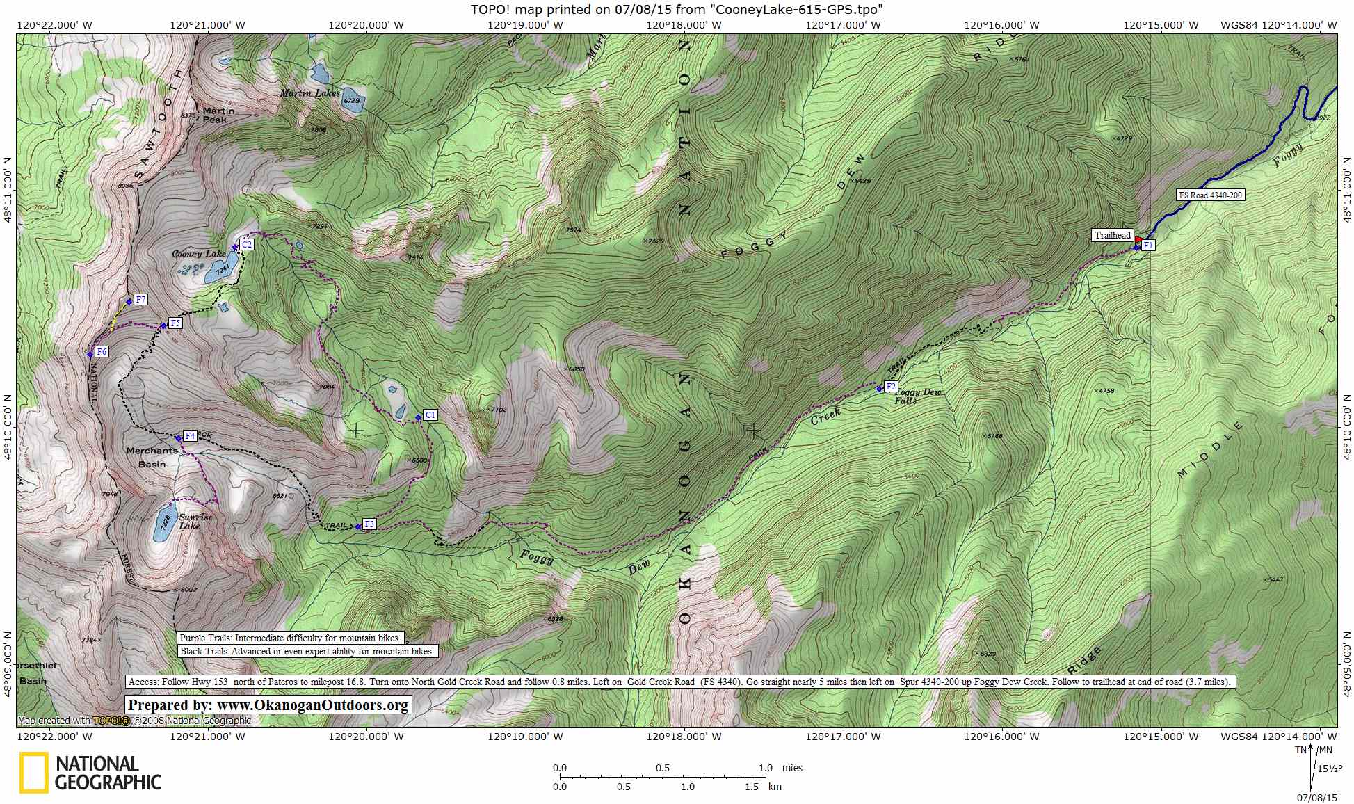
Details, Details: Cooney Lake via Foggy Dew Creek
Distance: To Cooney Lake is a 16.25 mile round trip. Once at the lake however you must hike up Angel’s Staircase to its highpoint at waypoint F6 or to the peak above Cooney Lake (Waypoint F7) for the views. This adds another 2.5 miles (roundtrip) and 1,000 vertical feet of elevation to the outing.

Elevation Gain. About 4,000 vertical feet to Cooney Lake and another 1,000 feet of gain to climb the 8,300-foot summit rising above the lake to the west.
Activities. Hiking, trail running, mountain biking, horseback riding.
Motorized Use. Motorcycles (dirt bikes) also use the trail and most of the trail maintenance on this trail system is performed by motorcycle clubs. Motorized use of the trails is light. ATVs are not allowed.
Skill. Hiking 1+ (advanced beginner). Mountain biking 2+ or 3- (advanced intermediate or easy expert). The trail is well maintained and fairly well signed. Mountain bikers will find the surface of the trail moderately loose and rocky.
Fitness. 2 (Intermediate) as an overnight trip. 3 (advanced) as a day trip.
Access. Follow Hwy 153 north of Pateros to milepost 16.8. Turn onto North Gold Creek Road and follow this 0.8 miles. Turn left onto Gold Creek Road (FS 4340) and keep going straight at the intersection with left branches. After nearly 5 miles, turn left at the Foggy Dew Campground and follow Spur 4340-200 up Foggy Dew Creek 3.7 miles to the trailhead at the very end of the road. There are no amenities at the trailhead and no permit is needed to park here.
Maps. See our topo map attached (this map is laid out in landscape mode for legal-sized paper).
GPS Info. Download this GPX file with the waypoints noted on our map.
Trip Instructions.
• From the trailhead, follow the trail uphill in a westerly direction for five miles. Foggy Dew Creek is always nearby during this time and there is a nice waterfall to enjoy after 2.9 miles. Strong mountain bikers with good climbing skills will be able to ride roughly sixty percent of the trail but the rocks and looseness of the surface will have even good cyclists pushing the bike quite a lot.
• At a trail intersection after 5 miles you can reach Cooney Lake by either trail option. If you’re hiker you’ll probably want to do a loop and see all the country. If you take the left fork you’ll head up into Merchant Basin. No motorized vehicles are allowed on this trail so the area sees less traffic and camping in Merchant Basin or at Sunrise Lake will be more peaceful. If you go this way reach Cooney Lake by going up to the pass at Waypoint 5 (2.1 miles) and then dropping down to Cooney Lake (0.9 miles).
• The easiest way to reach Cooney Lake is to go right at the trail intersection after mile 5 and follow the Martin Creek Trail 3 miles to the lake. This trail is well graded for easier hiking. Strong mountain bikers will be able to ride at least two thirds of this segment of trail.
• Once at Cooney Lake, work clockwise around the lake to head up the Angel’s Staircase to waypoints 5 & 6. Scramble up the peak to Waypoint 7 for the best view of all. This is the prettiest part of the hike and should not be forfeited. If you arrived at Cooney Lake by bike, very little of this final portion of the trip is ridable on the uphill and most of it is not ridable on the downhill by the average cyclist on a cross-country mountain bike (this is code for ‘leave the bike at the lake.’)
Other Trip Considerations. Mountain bikers may want to incorporate the trip to Cooney Lake and travel along Foggy Dew Creek in a big loop that starts at the Crater Creek Trailhead, goes up the Crater Creek Trail, turns onto the Martin Creek Trail and follows this to Cooney Lake. From the lake follow the Martin Creek Trail another 3 miles to the Foggy Dew Trail where you will descend the Foggy Dew Trail 5 miles to the Foggy Dew Trailhead. A car can be left at the Foggy Dew Trailhead or you can ride the roads about 9.75 miles back to the Crater Creek Trailhead. This post will help you piece together this loop.
Land Ownership. The route is all on Forest Service lands (Okanogan National Forest).
Date. This report was first posted 7/8/2015.
Leave It Better than You Found It. This should be every user’s goal. Do no damage and pick up trash left by others.
Disclaimer. Treat this information as recommendations, not gospel. Conditions change and those contributing these reports are volunteers–they may make mistakes or not know all the issues affecting a route. You are responsible for yourself, your actions, and your safety. If you won’t accept that responsibility, you are prohibited from using our information.
This article was originally posted on 07/08/2015.