
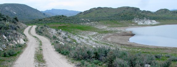
Apart from Omak Lake, Soap Lake at 157 acres in size (a quarter of a square mile), is the biggest saline lake in the Okanogan Highlands east of the Okanogan River and west of the Kettle River. Riding the gravel road to and beyond Soap Lake makes for an extremely pleasant outing, especially in spring when wildflowers color the adjacent hills. The dirt road leading to the lake has about a  1000-vertical-foot climb as you leave Highway 97. Stronger riders will want to tackle the climb for the fitness challenge. Less accomplished riders can easily avoid most of the climb and enjoy the flat portion of the road by parking up higher (described below).
The geology of this area is reason enough to visit Soap Lake. During the Pleistocene Epoch (2.6 million to 11,700 years ago) many periods of glaciation and interglacial melting occurred here. During the glacial periods most of British Columbia and Western Alaska was covered by the Cordilleran Ice Sheet some 4,000 feet deep. Different lobes of that ice extended south into Washington State and the Okanogan Lobe smothered much of Okanogan County east of the Cascade Mountains and west of the Kettle River in this portion of the Colville Reservation called the Okanogan Highlands.
The influences of glaciation in the Okanogan Highlands immediately east of the towns of Malott and Okanogan are particularly interesting. The ice lobe scoured canyons into the granite bedrock, exposed and polished other  slabs of granite, quarried huge boulders of basalt from ledges in the highlands and transported them (known as erratics) to new locations, and burrowed depressions into the ground where the surface was softer.
Once the ice retreated, colossal amounts of sand, gravel, and rock bulldozed by the glacier were deposited by the melting ice. Older drainages were plugged with all this glacial fill while haystack-like boulders from afar were scattered across the landscape. Ice and meltwater were also left in the many depressions carved in the earth by the glaciers and this provided water for the hundreds of little lakes that are strewn across these highlands like a sheet of glass shattered on a tile floor.
Most of these of these lakes are between 5 and 20 acres in size, and most have no outlets. Consequently the salts and minerals washing into these waters never leaves and they become saltier with time. Most of the lakes have also receded slightly over the past century so the exposed rocks rimming the shorelines are coated with a white crust composed of sodium carbonate, sodium bicarbonate, and sodium sulfate.
This country is not just geologically interesting — as you ride or walk or ride the region’s roads the folded nature of the topography, brilliance of the wildflowers, sparkle of the lakes, irregularity of  the erratics, and the open horizons of the rangelands are all pleasing to the eye. Especially if you visit in spring or autumn when the vegetation is most colorful, a form of magnetism will keep pulling you back.
Details, Details – Soap Lake Rides
Activity. Cyclo-cross or mountain bike ride.
Fitness: Depending on where you start the ride, this is rated a 1 (easy) or 2 (intermediate).
Skill: 1 (easy). The ride follows a wide, well-maintained gravel road.
 Access. Drive Highway 97 south of the town of Okanogan about 2 miles and turn left (east) at milepost 284 onto Simons Road. For a longer more strenuous ride, park out of the way at the bottom of Simons Road and ride this gravel road uphill. For a shorter, easier ride drive up Simons Road. After 1.5 miles and a second right angle turn, the road becomes Soap Lake Road (no signage actually notes this). Drive another 0.75 miles from this second sharp turn (2.25 miles from Highway 97) and find a pullout in the road to park. Most of the climbing is over and the road undulates now rather than climbs seriously.
Trip Instructions
- From where you park, simply keep riding Soap Lake Road south. About 4 miles from where you park (6.25 miles from Highway 97) you’ll reach the north end of Soap Lake.
- Keep riding the road south. Shortly past the south end of Soap Lake you’ll pass a small lake and about a mile past the south end of Soap Lake you’ll reach Little Soap Lake.
- Carry on past Little Soap Lake another 3 miles. There are no more lakes on this leg but the riding is still very scenic. When the road makes a sharp turn to the west and starts heading downhill (about 10 miles from the beginner’s start), less fit riders will want to turn around and retrace the route.
- Stronger riders may want to ride another mile farther (downhill) until Soap Lake Road intersects Highway 97. Here, you can then decide whether you want ride Highway 97 back to Simons Road (14.7 miles of flat, but busy, highway riding) or retrace the gravel road (perfectly quiet and significantly more scenic) back to the start.
Map. See our topo map.
Leave It Better than You Found It. This should be every user’s goal. Do no damage and pick up trash left by others.
Disclaimer. Treat this information as recommendations, not gospel. Conditions change and those contributing these reports are volunteers–they may make mistakes or not know all the issues affecting a route. You are responsible for yourself, your actions, and your safety. If you won’t accept that responsibility, you are prohibited from using our information.
This post was originally published on 4/9/15.

