![MissionPeak-lg[1]](http://wenatcheeoutdoors.org/wp-content/uploads/2016/06/MissionPeak-lg1-1.jpg)

This sprawling peak is the highest spot between Wenatchee and Ellensburg. With about 6,000 feet of vertical relief above the Columbia River, it sports awesome views for a peak of its size. For folks from Wenatchee, it’s close enough to leave town in the afternoon and be on the top for the sunset. For a little variety, it is possible make it an overnight hike and enjoy the nighttime lights of Wenatchee in the distance below as well as lights from Quincy, Moses Lake, Cashmere, Ellensburg, and Leavenworth. On a clear day you can see Mount Rainier, Glacier Peak and Mount Adams.
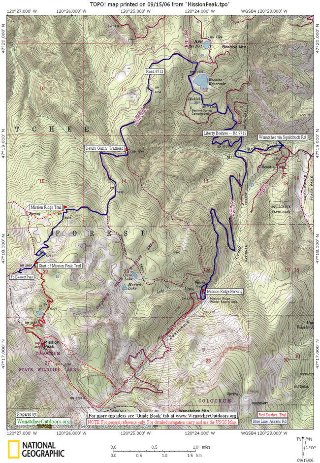
Maps: USGS Mission Peak. View our topo map below. Note: use ‘Print Preview’ before printing to properly scale this map to a full sheet of paper.
Activity: Hiking , trail running and mountain biking
Nearest Town: Wenatchee
Skill Level: 2 to 3 minus if accessing from from Mission Ridge. Level 2 from Rd 9712. There’s no signage, so map reading skills are required.
Fitness Level: 2
Distance: About 4 miles round trip from the access off of the Liberty Beehive Road (Road 9712).
Elevation: From the Mission Ridge Ski Area parking lot, the elevation gain is about 2,100 ft. From the Liberty Beehive Rd access, there is about 900 feet of elevation gain.
Recommended Season: Summer and fall


Access:
–Option 1: Follow Squilchuck Rd from Wenatchee toward Mission Ridge Ski Area. If you’re concerned about driving rougher roads or want a longer walk, drive all the way to the Mission Ridge Ski Area and park in the Mission Ridge Ski Area parking lot. (You’ll be walking up the ski area).
–Option 2: For a shorter walk, follow the Squilchuck Rd until you’re 1 mile past the Squilchuck State Park entrance and turn right onto the dirt/gravel Liberty-Beehive Road (Rd 9712). Follow road 9712 4.3 miles to the Devils Gulch Trailhead and then keep going as far as the condition of the road allows. In the fall of 2023, passenger cars could easily drive another 1.5 miles before the road got too rough for most vehicles other than Jeeps with very high clearance. Find a wide spot in the road to park and walk another 1.25 miles up the road to where our trip description for this walk begins. If you have a high-clearance vehicle, drive the entire distance to a benchmark noted on the map as 5868′ and then park on the side of the road. This is not a formal trailhead and no signage marks the beginning of the trail, so pay attention. The trail’s position in reference to switchbacks in the road make it easy to find. Total distance from leaving the pavement at the turn for Liberty-Beehive Road (Rd 9712) to the start of this trail is about 6.9 miles. Zero out your odometer right after you leave the pavement and use your odometer as your guide.
Trip Instructions:
–If parking in the Mission Ridge parking lot, ascend the ski slopes up toward the top of the ski area (upper area serviced by the Liberator Lift). Then walk cross-country in a northwesterly direction to the peak. This is a harder and fairly adventurous option that will have you relying on navigation and rock-hopping skills to find your way.
–If accessing from the the Liberty-Beehive Road (Rd 9712), follow an unmarked, blocked ‘road’ that ascends to the summit and was once used to access the now-gone lookout on top of the peak. Use our map for reference. This ‘road’ was decommissioned long ago and now feels much more like a trail than a road. There are intermittent intentional berms along this decommissioned road, which make it fun for young kids to run up and down.
–As of 2023, the trailhead is still well defined and in good shape. No signage marks the beginning of the trail, just look for the prominent trail leaving from the left hand side of the road when heading uphill. If you don’t see a distinct trail, you have likely not driven the road quite far enough. Use the odometer information above as your guide.
Additional Uses: Mountain bikers will find Road 9712 easy to ride which may encourage such users to leave their vehicle at the Upper Devils Gulch trailhead or at the Mission Ridge Trailhead farther uphill. The trail leading to the summit as described above is also quite ridable by intermediate riders until the last quarter mile where it becomes too rocky for most riders to contend with. Also note that there is some motorcycle (dirt bike) use of the trail, which is legal. Much of this trail’s maintenance is done by dirt bikers who, in summer, cut most of the deadfall that has fallen across the trail during winter storms.
Land Designation: Forest Service, and Fish and Wildlife.
Fees/Permits: None required
Trip Reporter and updates: First prepared by Charlie Hickenbottom on 9/25-26/04. Updated by: Jan Dappen on 9/2006, Sarah Shaffer on 9/6/2020, Andy Dappen 10/20/2023.
Leave It Better Than You Found It. This should be every outdoor user’s goal. Pick up trash left by others, pull some noxious weeds along your route, throw branches over unwanted spur trails, don’t ride or walk wet trails when you’re leaving ruts/footprints deeper than ¼ inch…
Disclaimer. Treat this information as recommendations, not gospel. Conditions change, and those contributing these reports are volunteers–they may make mistakes or may not know all the issues affecting a route. You are still completely responsible for your decisions, your actions, and your safety. If you can’t live with that, you are prohibited from using our information.