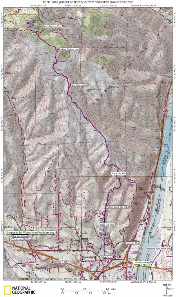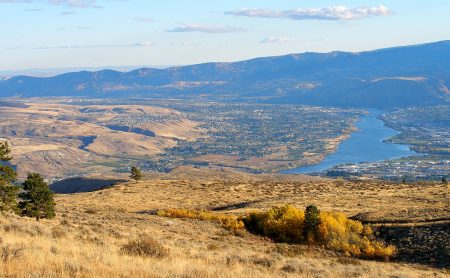
Attractions: Very close to town—many residents of Wenatchee can ride this road from their home. Beautiful views of the Cascades, Columbia River, and Wenatchee River. In early morning and late afternoon the sunlit ridges and shadowed faces of the foothills are gorgeous. You feel a world removed even though you’re very close to town.
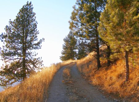
2023 Update. In year’s past, the ride up the unpaved portion of this road was a good test piece for mountain bikers. The dirt road was steep and relentless but offered good traction on the way up and fast rolling on the way down. Sometime around 2016, tons of fist- and golf-ball sized gravel was added to the surface of the road. This greatly reduced the erosion issues to the road caused by rain and snow melt, which has kept the road in better shape for cars. Unfortunately, the gravel has made for unpleasant biking — the surface is now looser and bumpier in both directions. Hardcore riders looking for a good workout are still encouraged to tackle this beast, but we’re betting it’s a road you may only decide to ride once — you know, for bragging rights. The unpleasant gravel stops 4.8 miles up the road and the dirt surface from that point on is much nicer to ride — meaning the Burch Mountain Beginner Ride remains a pleasant and worthwhile outing.
Activity: Mountain biking, trail running, walking
Nearest Town: Wenatchee
Skill Level: 2
Fitness Level: 3
Distance: The route described is 12.7 miles round trip. Parking at the bottom of the paved portion of Burch Mountain Road adds another 2 miles (roundtrip) to the ride. There are also other side roads to explore if you want to lengthen this ride.
Elevation: 3,420 feet from end of the pavement to top of Radio Tower summit
Recommended Season: Spring and autumn are prettiest, but the climb up the road is a good early-morning or evening workout in summer.
Access: From intersection of Highway 97 and Easy Street in the Old Station part of Wenatchee, follow Easy Street 0.2 miles north and turn right on Peters Street. Burch Mountain Road takes off to the left in another 50 yards. For a longer ride, park on the right side of Peter Street at the intersection of these two roads. Or turn left on Burch Mountain Road and follow it uphill for 1 mile until the pavement ends. Park on the left side of the road shortly before the pavement ends or in a small pullout (also on the left) about 75 yards farther uphill after the pavement ends.
Trip Instructions:
- Set the odometer at pavement’s end (elevation, 1,290 feet). Ride the main road uphill.
- Mile 1.15: A smaller road branches right and heads downhill. Stay on the main road and keep heading uphill.
- Mile 3.57: Pass a faint path taking off on your left. This trail is on private property and is closed to public use. Note: In the past, advanced mountain bikers have used this unofficial, eroded trail for a steep descent to Rolling Hills Lane. One the primary landowners whose property this trail traverses has contacted us and emphasized that this trail is closed. Occasionally signs noting that the trail is closed have been posted and some of these signs have been destroyed. This gives all recreationalists a black eye and merits stiff penalties (like castration) among those caught practicing such antics.
- Mile 2: Pass the driveways on each side of the road leading to homes.
- Mile 3.75: One Tree Lookout on your right (elevation 3,350 feet). For a shorter, less grueling ride, this is a good place to drive to and start your ride.
- Mile 4.5: A smaller, less traveled dirt road takes off on the right by the large, metal poles supporting the powerlines (elevation 3,790 feet). This road undulates (mainly contours) in what is generally a northerly direction. After 2.6 miles the road reaches a scenic overlook into Swakane Canyon. This road and its overlook provide a worthwhile alternative destination if you’re thighs are shot, and you want to reduce the day’s climbing by about 700 vertical feet.
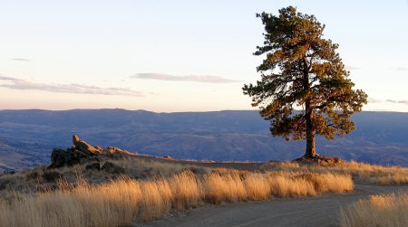
Tell me again — how did One Tree Lookout get its name? - Mile 4.9: The road momentarily flattens out as you enter the trees. There is a pullout and camping spot on the right (elevation 4,025 feet) that makes a good parking spot for those who come to walk or ride the Burch Mountain Beginner’s Ride. Note: Some Neanderthals use this area as a dump to discard couches, mattresses, and large appliances. This gives all recreationalists a black eye and merits stiff penalties (like castration) among those caught practicing such antics.
- Mile 5.5: Reach a major Y in the road. For this ride, go left.
- Mile 5.6: End of County Road sign and a gate. Motorized vehicles are not allowed beyond the gate. Ride around the gate and follow the main road up hill. (Note: To reach the radio tower just stay on the largest road, but to get fabulous views of Eagle Rock and Warm Springs Canyon, follow the road several hundred yards beyond the gate. Just before the main road switchbacks to the right, veer left. Climb gradually a few hundred feet to the ridge line and enjoy the drop-away view).
- Mile 6.35: Reach the radio towers on the top of the hill (elevation 4,720 feet). Check out the views in all directions before descending.
Cons/Hazards: In warm weather this is a long, hot climb with plenty of sun exposure. Bring plenty of water. The lower mountain has been degraded by steep, eroded, unsustainable spur roads.
Uses Allowed: Most of the road is open to both motorized and non-motorized use.
Uses Not Allowed: Motorized vehicles are not allowed through the gate at mile 5.6.
Land Designation: County road. The surrounding land is a mixture of private, State Wildlife, and Forest Service land.
Fees/Permits: None.
Dates and Reporter: This post was first prepared by Andy Dappen in 2005. He has updated the post in July 2008, March 2015, and September 2023.
Leave It Better Than You Found It: This should be every outdoor user’s goal. Pick up trash left by others; pull noxious weeds along your route; do not make or use new roads or new spur trails that were obviously user made. Do not use trails or roads when your footprints, horse prints, or wheel prints are more than 1/4-inch deep.
Important Disclaimer: Treat this information as recommendations, not gospel. Things change, conditions change, and those contributing these reports are volunteers–they may make mistakes, fail to give complete information, or may not know all the issues affecting a route. So forget about finger pointing: If things go wrong, you are completely responsible for yourself and your actions. If you can’t live with that, you are prohibited from using our information.