Riding from Cashmere, up Nahahum Canyon and descending Swakane Canyon to Rocky Reach Dam is a ride on secluded roads taking you from river to river (Wenatchee to Columbia). It’s also a ride taking you from hills of grass to hills of grass with beautiful forests of Douglas firs and ponderosa pines in between. Finally it’s a road that logs a lot of elevation gain at the start (2,600 feet) but delivers a 10-mile-long downhill coast to enjoy the fruits of your uphill labor. Along the way the ride delivers beautiful canyon scenes and the occasional long view out toward Twin Peaks and Mission Ridge.

Skill: 1+ (advanced beginners). Fitness: 2 to 2+(intermediate to strong intermediate).
Bike recommendations. If you shuttle a car to the mouth of each canyon and mainly stick to the low-traffic roads of Nahahum and Swakane canyons, then doing the route on a mountain bike makes the most sense (a cross-bike would still be OK). If you’re relying on just one car or no car at all, then a cross bike makes a lot of sense to gobble up the pavement more easily.
Recommended direction. For the purposes of this ride we recommend starting this ride by driving to Martin’s Market (at Cashmere’s easternmost traffic light along Highway 2). We also recommend leaving a shuttle vehicle at Rocky Reach Dam or in a large pullout at the bottom of Swakane Canyon (off Highway 97A about 5.5 miles north of Sunnyslope in Wenatchee).
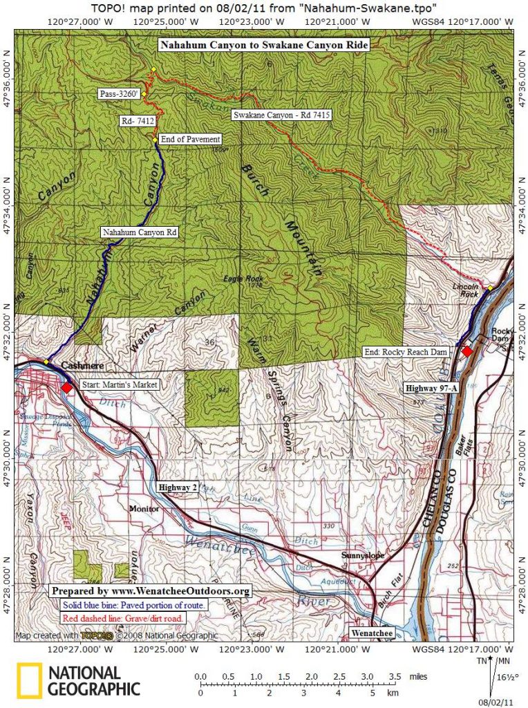
Map. See map below for more information.
Trip Instructions. ( The first half of these directions are taken from another ride prepared for WenatcheeOutdoors by Larry Glickfeld).
- Mile 0.0 , elevation 780’. From Martin’s Market at the east end of Cashmere, go north across Highway 2 and immediately turn left (west) onto the paved Frontage Road.
- Mile 0.8. Turn right onto Nahahum Canyon Rd. and start a long, steady climb on pavement, through mostly private farm or ranch land.
- Mile 6.0, elevation 2400′. Road turns to dirt (Forest Road 7412) and climb steepens considerably. Terrain remains open.
- Mile 7.2, elevation 3250′. Reach the saddle at the top of this route. There’s a road junction here. Go straight and almost immediately start descending. Note: On future rides take the left road here which has many options for riding over to Olalla Canyon, Eagle Creek, and the ridge road along the top of the Entiat Mountains.
- Mile 8.1 elevation 3,000’. In the Beaver pond area take a hard hook to the right ( southeast) and follow Swakane Creek (downhill). Now just keep following the creek drainage downhill for the next 8.4 miles.
- Mile 16.5, elevation 775’. Turn right on Highway 97A and ride about 1 mile to where you left the car at (or near) Rocky Reach Dam.

Other resources. See this MapMyRide data about this ride prepared by Ray Birks. (Note: On the first screen of this route, click the ‘3D-Flyover video’ link that stitches together aerial photos – very cool.)
Trip Options. To make a longer ride (particularly suited to cross-bikes) don’t use a car at all and do the trip entirely on bikes. Or use the bus (Link Transit) to catch the bus from Wenatchee to Cashmere, using Route 22..
Trip Reporters. Prepared by Ray Birks with notes from Larry Glickfeld. Posted 8/2/2011.
Leave It Better than You Found It. This should be every user’s goal. Pick up trash left by others, pull noxious weeds along your route, throw branches over unwanted spur trails, etc.
Disclaimer. Treat this information as recommendations, not gospel. Conditions change and those contributing these reports are volunteers–they may make mistakes or not know all the issues affecting a route. You are responsible for yourself, your actions, and your safety. If you won’t accept that responsibility, you are prohibited from using our information.