
Attractions. Long (31 miles) and tough (5,000 feet of elevation gain), but non-technical (all on gravel roads) this is a good route to tackle if you want something that is physically hard but technically easy. With canyons, ridges, forests, summits, and long views… it’s also scenically varied.

Parts of this ride span miles of forests that were overrun and cooked by the fires of 1994. Even though some of these lands were ravaged, this part of the ride is interesting to see and to ponder fire’s role here in the dry forests of Central Washington. Other parts of the ride follow high ridges with long views in all directions out over the snow-capped summits of the Cascades. Those peaks in the background framed by dense patches of wildflowers in the foreground will make this ride well worth the liters of sweat sacrificed to the effort.
Distance: About 31 miles. Elevation Gain: about 5,000 vertical feet.
Fitness: 2+ or 3 (strong intermediate to advanced).
Skill: 1+ (advanced beginner).

Access. From Wenatchee, travel north on Highway 97A toward Rocky Reach Dam. About a mile north of the dam, turn left (west) on Swakane Canyon Road. Follow this about 3.2 miles and park near a pole barn (hay storage building) located on the left side of the road. Look for Road 5215 on your right (usually gated). No permit needed to park (elevation: 1,380 feet).
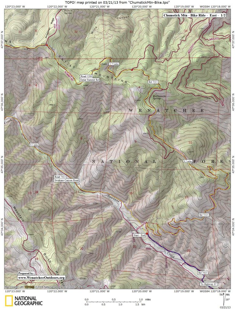
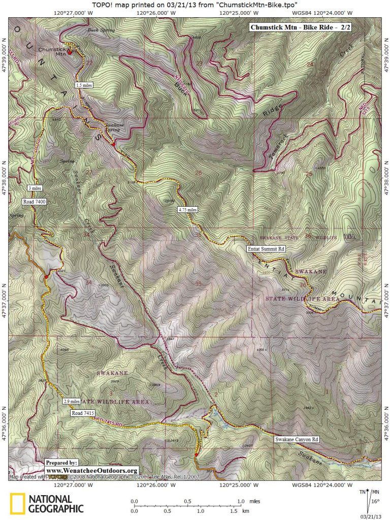
Maps. See maps below for more information.
Map 1 (eastern ends of the route). Map 2 (western portion of route).
Printing tip: Use ‘Print Preview’ to properly orient and scale paper before printing.
Trip Instructions:
- Follow Road 5215 as it climbs relentlessly for 8.5 miles to an intersection at 4,275 feet with the Entiat Summit Road (Road 5200). You’ll pass a few spur roads during this leg, but stay on Road 5215 (the main road).
- Turn left on Road 5200 and follow this 2.7 miles (after one mile this becomes a very scenic road following a high ridge) to an intersection with Dinkleman Ridge Road at an elevation of 5,070 feet.
- Turn left and continue following Road 5200 (aka The Entiat Summit Road) for 4.75 scenic miles along the ridge of the Entiat Mountains to an intersection where Road 7400 branches left and Road 5210 branches right (el: 5,140 feet). Later, you’ll be coming back to this spot and following Road 7400.
- Go straight through this intersection. In 1.25 miles (on the northwest side of Chumstick Mountain), take a road branching off to the left and follow this 0.25 miles to the summit of Chumstick Mountain (el: 5,810’).
- Return to the intersection with Road 7400 mentioned two steps earlier and turn right (northwest).

A few downed trees on the route, but a nice way to stretch the legs. Pictured is Sarah Shaffer. Follow Road 7400 for 3 miles, passing a few spur roads.
- Reach a T- intersection and turn left (south) onto Road 7415. Follow Road 7415 for 2.9 miles to the pass (3,250’) between Nahahum Canyon to the south and Swakane Canyon to the north (left).
- At the pass, hook sharply to the left — this actually keeps you on Road 7415. Head north and downhill into Swakane Canyon. After 0.75 miles, the road crosses Swakane Creek, hooks sharply to the right, passes some beaver ponds (which will be on your right). Keep following the road and Swakane Creek downhill.
- About 6.1 miles from the pass (5.25 miles from the beaver ponds), you’ll return to the car.
Special Equipment. Bring the normal repair kit and survival essentials. In late spring and summer this ride can be hot and you’ll harvest lots of sun. Bring a few quarts of water and water purifier (iodine or Aquamire) in case your Camelbak runneth dry. You will pass water along the way but some of the options are of questionable purity.
Land Designation: Forest Service
Fees/Permits: None needed.
Trip Reporter: Andy Dappen from 2007 notes with 2012 updates. Updated again on 5/27/21 by Sarah Shaffer.
Current Route Status: As of 5/22/21 there are a few sections of trail that you may have to dismount your bike to go around downed trees. We are assuming many of these downed trees will be taken care of by mid-summer by motorized vehicles or dirt bikes, but in any case, be warned you may have some hike-a-bike sections.
Leave It Better than You Found It. This should be every user’s goal. Damage nothing, pick up trash left by others, pick noxious weeds found along the way…
Disclaimer. Treat this information as recommendations, not gospel. Conditions change and those contributing these reports are volunteers–they may make mistakes or not know all the issues affecting a route. You are responsible for yourself, your actions, and your safety. If you won’t accept that responsibility, you are prohibited from using our information.