Twin Peaks (aka Horse Lake Mountain) is the not-so-secret yet secret backyard of both Cashmere and Wenatchee. Not-so-secret because local hikers and mountain bikers know it’s there. Yet secret because, apart from the frequently used roads to the summit and a few branch trails (e.g., Suspended in Paradise), there are many square miles of terrain that feel surprisingly lonely. Up here you can feel a world away from town when, in fact, you’re a very short distance from Cashmere or Wenatchee. Furthermore, in summer the temperatures in the forests gracing the peak are frequently a world removed from the rubber-melting heat down in the valley.
This post lists a variety of rides/hikes around Twin Peaks of different lengths and different difficulties, although it is still not a comprehensive cataloging of all the trails on Twin Peaks. Be sure to couple these route descriptions with the maps we’ve prepared. Also, be aware that some of these routes are described in greater detail in the guidebook under such titles as Twin Peaks-Main Road, Twin Peaks-Butler Ridge and/or Twin Peaks-Mission Overlook.
Distance and Elevation: Routes of various length are described below. You can estimate the vertical gain of different routes by noting the elevation of these landmarks: Cashmere (el. 800’), Wenatchee Racket and Athletic Club (el. 1,000’), end of pavement up Number Two Canyon Road (2,525’), second gate along FS Road 7101 (2,970’), West Summit (4,621’), East Summit (4,586’).
Access: Start from Wenatchee or Number Two Canyon Road (above Wenatchee). If starting from Wenatchee, follow Western Avenue south until it hooks sharply to the right to become Number Two Canyon Road, and ride the road. If driving to reduce the outing time, drive 4.25 miles up Number Two Canyon Road and park at pavement’s end in a pullout on the south side of the road (the small parking area on the north side of the road is private and is not to be used). You can also drive another 0.7 miles past the end of pavement and park at the second gate where the dirt road you’ve been following (FS Road 7101) makes a sharp hook to the left. The condition of the dirt road changes each year depending on how badly it has been rutted by mudders — sometimes high-clearance vehicles will be needed, sometimes not. No permits are needed to park at either of these parking areas.
Directional Strategy. If you’re mountain biking (or on a cross bike) and riding a south-side option or any long outing that takes you over the summit to complete a Cashmere-to-Cashmere or Wenatchee-to-Wenatchee circuit, riding up the peak via Number Two Canyon Road (out of Wenatchee) makes the most sense. Climbing the peak via the main Twin Peaks Road on the south side of the mountain is, by far, the easiest way to ascend the peak and is completely ridable the entire distance.
Issues: 1) Quite a number of singletrack trails on Twin Peaks are user made and were not developed through a formal process the land owner or land manager endorsed. Some of the land managers are aware of these trails on their property and have allowed them to remain, but continued covert trail building jeopardizes what’s being used now. The Forest Service is also working on a trail plan to develop a series of nested loop trails on the south side of Twin Peaks offering rides/hikes of various length and difficulty. Continued covert trail development will be under more scrutiny as the trail plan is developed and could easily erode goodwill between the Forest Service and user groups trying to work cooperatively with the agency. 2) Stay on established trails and stay off paths that are obviously damaging to the terrain. 3) Loose trails that plummet straight down the fall line of steep slopes may be fun to ride/hike, but the ruts formed by such use become channels for rainwater and quickly erode into unsightly scars. This kind of damage angers land owners / managers and creates a PR problem for the recreation community.
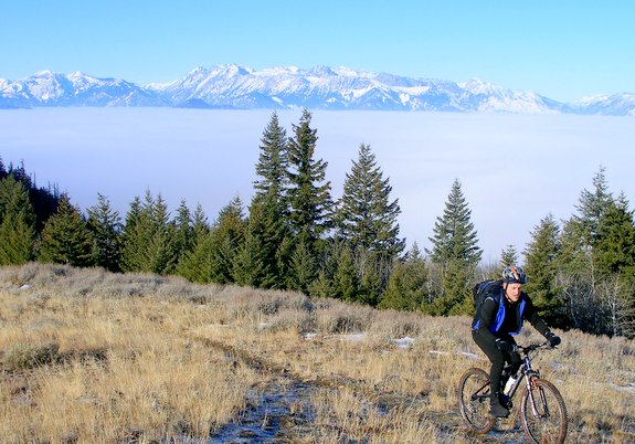
Best season: Spring, summer, and fall. The top of Twin Peaks can be surprisingly cool when it’s hot down in the valley, so this is a nearby place to escape when the mercury spikes.
Uses allowed: mountain biking, hiking, trail running.
Uses not allowed: Motorized vehicles are not allowed on the Twin Peaks Road nor on any of the trails accessed by this road on the south side of the summit nor near the summit on the north side of the peak. Trails leading down into the Sage Hills area (east and northeast side of Twin Peaks) are also closed to motorized recreationalists
Land designation: The various rides below cross a mixture of Forest Service, DNR, BLM, and private timber lands. Over on the northeast side of Twin Peaks (lands leading down into the Sage Hills), the Chelan-Douglas Land Trust is the principle owner of lands with trails.
Fees/Permits required: None.
Date of Report. This report was first prepared in May, 2008. When noted, the information was updated in August 2013.
Leave It Better Than You found It. Pick up trash left by others, pull noxious weeds along your route, disperse old fire rings (they encourage more fires), throw branches over spur trails and spurs between switchbacks (make it harder to do the wrong thing than the right thing), don’t go off trail…
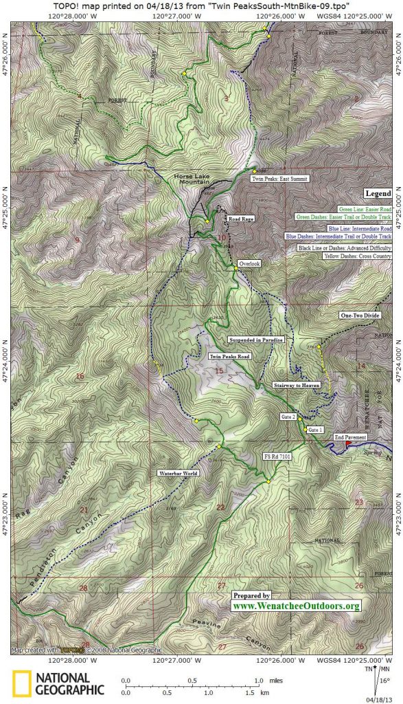
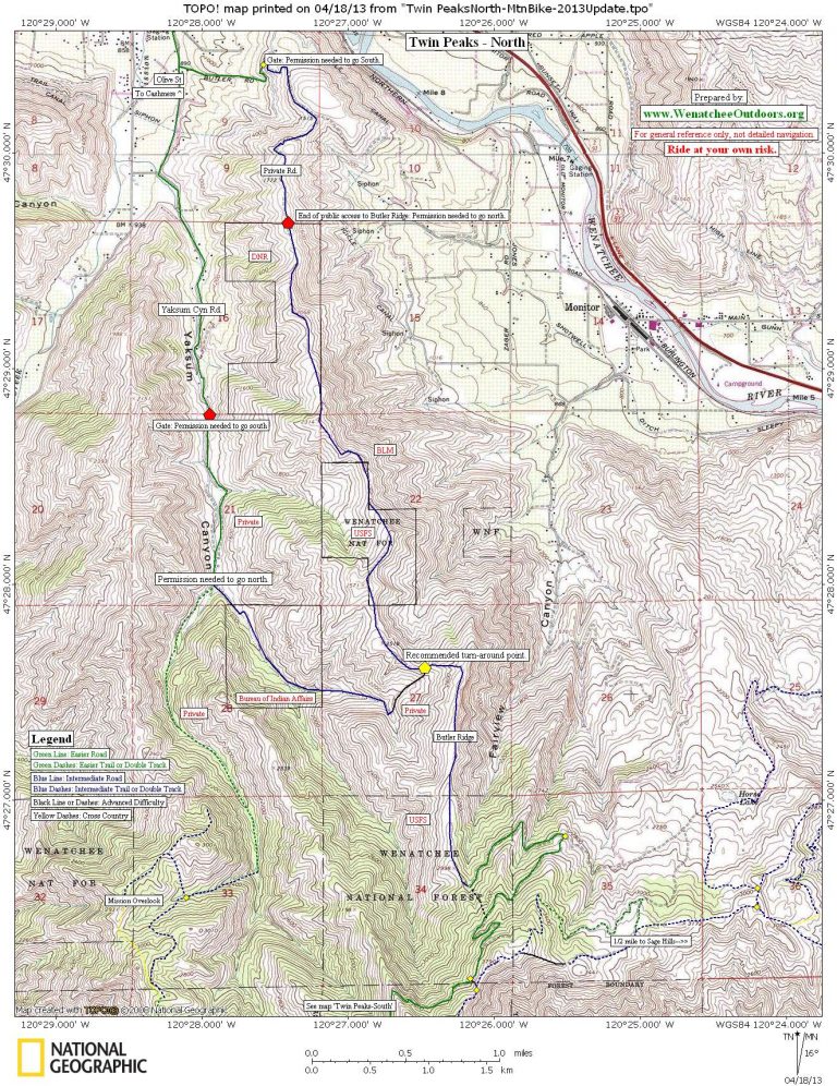
Maps: See maps below for more information. 1) Twin Peaks- South 2) Twin Peaks- North.
Both of these maps are laid out for legal sized paper and should be printed in portrait mode.
Use your ‘Print Preview’ to properly scale the maps before printing.
Our maps are derived from USGS 7.5-minute quads for 1) Monitor 2) Cashmere.
TRIP OPTIONS
Twin Peaks Road to East Summit. This road is closed to motorized vehicles at the second gate along FS Road 7101 and climbs steadily (but at a reasonable pitch) to the top. Technically, it’s an easy road to ascend and descend, but it still requires a good level of fitness crank up. At the second gate (0.7 miles after Number Two Canyon Road turns to dirt), go around the gate and onto the slightly smaller road beyond that is closed to motorized vehicles. Mile 0.4: The road hooks left by the foundation of an old building which is on your left. The trail coming in on your right is the lower end of Suspended in Paradise. Mile 1.85: The road passes the Number One Canyon Overlook. The overlook is to the right of the road and this is where the upper end of Suspended In Paradise connects to the main road. Mile 2.45 (at the second right-trending switchback after the overlook): Look to your left and notice a faint spur trail on the bank—this allows access to trails on the south shoulder of Twin Peaks. Mile 2.7: Road Rage, a fairly new trail, leaves from a big left-trending switchback. Mile 2.85: (el: 4,280’): Immediately after a shoulder with an expansive view out toward Mission Ridge, reach a Y in the road and go right (the left fork is used to access other trails and roads mentioned later that contour around to the north side of the mountain). Mile 3.3: A single-track spur branches right and, in a few hundred yards, reaches the East Summit. Mile 3.35: If you missed the single-track, you’ll come to a Y. Go right and you’ll reach the summit of the East Peak in a few hundred yards (the left road traverses north and can be used to access Butler Ridge or trails leading back to the Sage Hills.
Suspended in Paradise. Ride the main Twin Peaks Road as described above to the Number One Canyon Overlook (1.85 miles after the second gate). Turn right off the road and ride about 30 yards toward the overlook. Turn right on double-track heading southeast along the rim of Number One Canyon. After 0.3 miles, go through a little gap on the left rather than climb to the summit of a knoll and start a fast descent on a good trail. The trail beelines downward, goes straight across a few spur roads, and reconnects with the main Twin Peaks Road. The entire distance from the overlook to where you reconnect with the main road is one mile. Note: In 2011, the Forest Service road forming the foundation of this trail was officially decommissioned. As of 2013 some unofficial jumps and features are being developed in this corridor, but much of the main descent of what used to be Suspended in Paradise is not very rideable.

South Shoulder Rides. You can access the south shoulder of the peak from several different places. The hardest technical lines are also the ones that are most irresponsible to ride–they leave from the West Summit and follow loose, rocky, and somewhat indistinct treads straight down. There’s need for a well-designed trail here that’s more than a controlled skid down the fall-line and that will become more than an ugly scar that’s a channel for rainwater.. You can access the south shoulder at a place that isn’t quite so erosive and damaging to ride a bit down from the summit by following the main Twin Peaks Road to the Y at Mile 2.85 (see description above). Go left at the Y and ride west a few hundred yards. Just before the road hooks north, look for a cairn and turn left (downhill). The trail is initially non-distinct but it improves as you drop. There’s also a lower access to the trail if you leave the main Twin Peaks Road at Mile 2.45. Carry the bike up the bank confining the switchback and along a narrow traverse. Then contour southwest 100-plus yards to intersect the trail dropping down the shoulder. Regardless of where you access the shoulder, the trail eventually peters out part way up Knoll 3,038’ (see map). We’ve found it easiest to push half way up this knoll and then bushwhack along a very old road bed to reach the opposite side of the knoll and to connect with the Ridge and Meadow Loop (described below).
Stairway to Heaven. Arguably the most popular trail on Twin Peaks. We have a guidebook entry written up about this trail at this link.
Waterslide. Ride to the Number One Canyon Overlook about 1.85 miles above the second gate. Continue riding up the road for about 100 yards to where a singletrack trail drops down to the left. This is the lower entrance to Waterslide, and intermediate riders will prefer this entrance. Ride down this fairly level trail for 0.1 miles until it merges with the upper entrance to Waterslide. For those wanting a longer, more advanced descent, ride up the road for 0.2 miles from the overlook. At a right-turning switchback, look for a trail descending to your left into the trees –this is the upper entrance. Drop in and follow this narrow, sidehilling trail for 0.3 miles to where it intersects the lower entrance. No matter where you start, the best riding is below where the two entrances merge. You’ll drop south into a little canyon, where the trail makes a lightning-fast beeline downward. An array of berms and features for stunts line the trail. Eventually you’re spit out onto the Twin Peaks Road about 0.9 miles from the intersection of the upper and lower entrances.
Road Rage. Ride to the Number One Canyon overlook at about 1.85 miles after the second gate. From the overlook, continue to climb up the road for one more mile, where Road Rage will drop directly to your right into fire-charred forest at a left-trending switchback. Beginning on an old road bed, descend through a series of tight twists and turns that will test your mountain bike abilities. For much of it’s one mile length the trail is loose and narrow, sometimes making use of a long-abandoned logging spur. Reach the Number One Canyon Overlook after a technical and exciting descent. After riding down Road Rage a few times, ride up it — it’s a technical ascent and good climbers can ride most of it without touching down. We suspect excellent climbers can ride all of it.

Butler Ridge (Advanced-Intermediate Route). This is a spectacular ridge system on the north side of Twin Peaks and a highly recommended descent. The ridge is an undulating ride along a series of knolls that lead you toward Cashmere. However, the northern end of the ridge is private property, and without advance permission from the landowners it’s no longer possible to legally traverse the ridge all the way to Cashmere. Nevertheless, this is a beautiful out-and-back ride— just be sure to save energy for the return. The most direct line to Butler Ridge is to take the left spur off the Twin Peaks Road at Mile 3.35 (just before the East Summit). Ride north on flat terrain for 0.4 miles and then start dropping down a steep, rocky road for another 0.45 miles until you intersect a much newer road. Turn right and, after a few hundred yards, reach the end of a logging platform. Plunge down a single-track trail leaving from the end of this platform following a northeastern ridge system. After 0.4 miles, the narrower trail merges with a very rough and rocky old road. Ride or walk down this road about 150 yards to a T- intersection with a good dirt road and turn right. Switchback down this good dirt road for about 2.2 miles to get onto Butler Ridge–there are several roads branching off the route you need to follow, so pay close attention to the map to stay on course. Once on Butler Ridge, stay on its crest for about 2.5 miles to a saddle with a T-intersection at 2,450 feet. The left trail descends into Yaksum Canyon and reaches pavement after 2.75 miles. Most of this trail is on private property and is not to be riden without advance permission from Walter Hills (425-888-0412). However, with Walter’s permission you can take this trail to Yaksum Canyon Road, which will descend into Cashmere. From Cashmere you can either hop a bus to Wenatchee or ride home via orchard roads. If you do not have permission to ride to Yaksum Canyon Road, this saddle is a good spot to turn around. Update as of 2012: After the saddle, Butler Ridge is publicly accessible for another 2.7 miles, but you will have to turn around after the last parcel of DNR land. This ride can no longer be done as a full traverse of the ridge, as the north end of Butler Ridge has no legal public outlet. The ridge ends on private property, and is gated at the Butler Road entrance.

Butler Ridge (Easy-Intermediate Approach). This approach gets you onto Butler Ridge by following a network of good logging roads that contour the mountain. The distance is greater, but the elevation gain and technical difficulties are lower. Ride the main Twin Peaks Road to Mile 2.85 and go left at the Y in the road. The road climbs slightly to the west, contours, and then drops steadily. Mile 4 (el. 3,900’): Reach a saddle where several roads intersect. Turn right and ride what is mainly a descending contour. A few spurs branch off this road–stay on the main road as it trends east and northeast (this road occasionally climbs a bit). Mile 6.75: A very steep spur road comes in on the right (el. 3,620’ feet)–this is where the rough, rocky old road from the intermediate approach (above) merges with this easier route at a T intersection. Now follow the route as described above.

Mission Creek Overlook (Point 2,931’). Ride the Twin Peaks Road to Mile 2.85 and take the left fork in the road. The road climbs slightly, contours, and then drops steadily. Mile 4 (el. 3,900’): Reach a saddle where several roads intersect, turn right, and ride what is mainly a descending contour. Mile 5.65: Intersect spur 7107-200 (el. 3,480’), turn left, and continue descending while passing a few overgrown spurs. Mile 7.65 (el. 3,100’): At a Y in the road where the left branch climbs, stay right and keep descending. Mile 8.05 (el. 3,050’): At a platform where the road going right becomes less used, turn left onto a decent single-track path (for intermediate riders this trail can be tricky—it gets moderately steep). Soon, the trail merges with another road–follow this road as it undulates a little and then drops. Mile 9.5 (el 2,600’): At a T-intersection, turn left and climb steeply 0.2 miles up a draw to a saddle. At the saddle, turn left and climb another 0.2 miles up to Point 2,931’ where you can enjoy views over the Mission Creek watershed and the Enchantments. Return by retracing the route.
Waterbar World. Don’t go through the second gate onto the Twin Peaks Road. Instead, take the sharp left bend in FS Road 7101 and ride 0.6 miles up to the saddle dividing Number 2 Canyon from Mission Creek. Take a right (Road 7101-111) and keep riding uphill in a northwesterly direction another 0.8 miles. A variety of spurs branch off left and right—avoid those that are overly steep or overly flat. At a pullout where the road jogs right, drop over the bank onto single-track. The route drops toward Mission Creek and gives you about 2 miles of enjoyable trail riding before it intersects the road bordering Mission Creek some 2 miles upstream of the Lower Devils Gulch Trailhead. Take a left and head up Mission Creek on the road. Within a quarter of a mile, take a left onto Road 7101. Ride uphill staying left at the next Y (1.25 miles away). About 2.6 miles after leaving Mission Creek, you’ll return to the saddle between Mission Creek and Canyon Number Two.
Ridge and Meadow Loop. Ride Road 7101-111 (see Waterbar World) to its end about 0.3 miles beyond the start of Waterbar World. The end of the road is marked by a parking area that looks down on Mission Creek. At the northern edge of this parking area a trail takes off in a northwesterly direction, follows the ridge system for a short distance, and then plunges down into the big meadow bordering the lower stretches of the Twin Peaks Road. Once down in the meadow, many people ride up the Twin Peaks Road to complete a circuit of Suspended in Paradise.
Important Disclaimer: Treat this information as recommendations, not gospel. Things change, conditions change, and those contributing these reports are volunteers–they may make mistakes, fail to give complete information, or may not know all the issues affecting a route. You are still completely responsible for yourself and your actions — if you can’t live with that, you are prohibited from using our information.
This post was first prepared in 2008 but keeps getting updated as we become aware of changes, new trails, and issues. Some updates added 5/15/2015.