This road ride takes you through the Wenatchee River Valley between Leavenworth and Wenatchee with only a few miles of exposure to Highway 2. The ride takes you through the orchards and below the foothills of the Wenatchee Valley, making it both a scenic training ride as well as an enjoyable outing with friends or family. The difference is simply in the speed at which you attack the route. The majority of the ride is on frontage roads or along orchard roads where the traffic is light. The ride is especially enjoyable in spring when the orchards are in bloom, and in autumn when pears and apples are ready to harvest.
SKILL. 2 (intermediate). FITNESS. 2+ (strong intermediate)
DISTANCE: Roundtrip distance from Confluence Park in Wenatchee to downtown Leavenworth (or going the opposite direction) is roughly 55 miles.
ELEVATION GAIN: Unknown. The route climbs and descends a number of hills.
TRIP DESCRIPTION:
Editor’s Note: Distance figures quoted below are all approximate. We’ve broken down the trip into two sections — Wenatchee to Cashmere and then from Cashmere to Leavenworth. If you’re doing the ride from Leavenworth to Wenatchee, ride these roads in reverse order take turns the opposite direction.

WENATCHEE TO CASHMERE
-
Follow The Loop to Confluence State Park.
-
At Confluence, follow the entrance/exit road out of the park.
-
Left on Old Station Road. Go 0.45 miles.
-
Right on Chester Kim Road to avoid the traffic merge at the top of the ramp to Easy Street.
-
Left on Penny Street. Go under freeway and continue straight on Cordell Avenue which hits Chatam Hill Dr.
-
Right on Chatam Hill Drive, follow it uphill in a Northwesterly direction. It merges seamlessly with Lower Sunnyslope Road. Go roughly 1.75 miles.
-
Left on Sleepy Hollow Road (if you hit the freeway you’ve gone 0.25 mile too far). Go 2.75 winding miles until it terminates in a T intersection.
-
Left on East Richared Road. Go 0.45 miles.
-
Right on Richared Drive. Go 0.25 miles.
-
Right on Fairview Canyon Rd. Go 0.35 miles.
-
Left on Warehouse Road or Pioneer Way. Cross intersection in Monitor, staying on Pioneer and heading out of town in a NW direction. Go 0.45 miles to an intersection where Monitor Orchard Road branches off to the left. Two options from here.
Option 1. Veer right on Pioneer which will become Old Monitor Road. Cross the wooden-planked bridge, then wind uphill. About 1.6 miles from the intersection, reach the Anjou Bakery where Old Monitor Road hits Highway 2 (the bakery is a popular stop for cyclists). Turn left on Highway 2 and go 1.3 miles. Turn left at the stoplight and head into Cashmere on Cottage Avenue. Go 0.7 miles to downtown. At Division Street turn left.
Option 2. Veer left on Monitor Orchard Road and go 0.3 miles. Turn right on Zager Rd, go a few hundred yards and the road then bends hard left, go a few hundred yards more. Turn right on Kelly Road (this is poorly signed, but if you go straight the road becomes Barden James Road). Follow Kelly Road uphill for 0.35 miles before it bends left and becomes a dirt road for 0.75 miles as it drops down toward the Wenatchee River. Near river level, Kelly Road becomes paved again and merges seamlessly with Riverfront Drive. Follow Riverfront Drive 2.5 miles. Turn Turn left at Cottage Avenue (aka Cotlet Way) and ride 0.6 miles into downtown. At Division Street turn left.
CASHMERE TO LEAVENWORTH
Option 1
-
From Division Street, turn right onto Sunset Highway and ride west out of town. Go 1 mile.
-
Right on Goodwin Road. Go 0.4 miles to Highway 2.
-
Left on Highway 2. Go 1.5 miles.
-
Right on North Dryden Road. Go 4 miles. The road climbs, twists, and drops. West of Dryden it merges with School Street shortly before hitting Highway 2 again.
-
Right on Highway 2. Go 2.5 miles to the traffic light outside of Peshastin.
-
Right on Main Street. Go 0.35 miles across the bridge and through town.
-
Left on North Road. Go roughly 4.5 miles.
-
Left on Highway 209. Go 0.5 miles.
-
Right on Highway 2. Go 0.5 miles to reach the center of Leavenworth.
Option 2. Some will prerfer doing this option traveling from Leavenworth to Wenatchee because the hill climbs aren’t as steep in this direction.
-
From the intersection of Division Street and the Sunset Highway in downtown Cashmere, follow the Sunset Highway west out of town. Go roughly 4 miles (in the last third of this stretch, the Sunset Highway merges and becomes known as Stines Hill Road).
-
Fade left on Kinney Road. Go 0.4 miles.
-
Right on Pine Flat Loop Road. Go 0.3 miles.
-
Straight on Johnson Rd. Go 0.4 miles.
-
Straight ahead on Deadman Hill Rd (a steep climb followed by a steep descent). Go 2.1 miles.
-
Left on Highway 2. Go 1.75 miles to the Peshastin traffic light.
-
Right on Main Street. Go 0.35 miles across the bridge and through town.
-
Left on North Road. Go roughly 4.5 miles.
-
Left on Highway 209. Go 0.5 miles.
-
Right on Highway 2. Go 0.5 miles to reach the center of Leavenworth.
HAZARDS: Most of this ride is along small frontage roads and orchard roads. The shoulders of some of these roads are narrow or non-existent but the traffic is light. Small sections of the route hit Highway 2 where the traffic is heavy and fast but the shoulder is wide.
RECOMMENDED SEASON: Spring, summer fall. Even during the hot months this can be a pleasant ride in early morning or evening.
BUSES: One way for less fit cyclists to complete this ride? Bike one way and use the bus (Link) for the other leg. Scheduling is often easier if you take the bus first and bike back. Get the bus schedule before taking this ride by calling 662-1155 or visiting www.linktransit.com. As of June 2010, you’ll want to check Route 22 in the direction you’ll be busing. The bus ride between Wenatchee and Leavenworth costs $2.00 (verify rates). On Saturdays, buses run about once every 75 minutes between 8 a.m. and 6:30 p.m. On week days, buses run more frequently, start earlier in the morning, and continue later into the evening There’s NO bus service on Sundays.
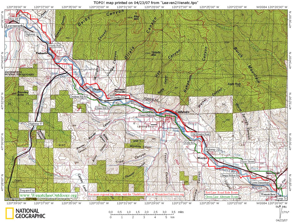
MAPS: See map below for more information.
TRIP REPORTER: Andy Dappen, 4/23/07. Corrections from Jack Evans added 6/15/2010.
Leave it Better than You Found It. This should be every user’s goal. Pick up trash left by others, pull noxious weeds along your route, etc…
DISCLAIMER. Treat this information as recommendations, not gospel. Conditions change and those contributing these reports are volunteers–they may make mistakes or not know all the issues affecting a route. You are responsible for yourself, your actions, and your safety. If you won’t accept that responsibility, you are prohibited from using our information.