Ray Birks submitted this road bicycling route with photos on the Forum. We liked his clever use of the Link bus to make climbing Badger Mountain easy on the muscles and on the gas tank. We thought his insights would be valuable to other cyclists, so we nabbed the information from his short trip report to craft a guidebook entry.
The Forum has simple buttons where you can post condition and trip reports from your own trail sport, biking, climbing, snow sport, paddling, and wind sport outings. Could there be an easier way to earn 15 minutes of fame?

Ray Birks wrote: “I took the bus to Waterville for $2.50 and rode home via Badger Mountain Road. It was a beautiful trip in the sunshine most of the way with very little traffic and tremendous views. I mostly wanted to ride the dirt road on the Waterville side of Badger Mountain on my cross bike, but the whole trip was relaxing and well worth the $2.50 investment.”
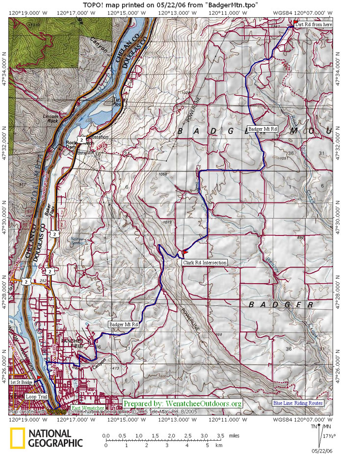
Maps. See map below for more information. This map is co-opted from the Badger Mountain Family Ride and doesn’t show the full access from Waterville, but does give a complete view of the ride down Badger Mountain Rd.
Note: Use ‘Print Preview’ to orient/scale the map before printing.
Activity: Road Biking
Nearest Town: Waterville, Wenatchee
Skill: 1 (beginner)
Fitness: 2+ (intermediate/advanced)
Distance: 27 miles.
Elevation Gain: 1,712 feet.
Best Seasons. Spring (when the wildflowers are blooming) and fall (when the vegetation is golden) are particularly beautiful. Nonetheless, this is still a nice early morning ride in summer because the morning air and higher altitudes work in tandem to take some of the singe out of the desert heat.
Access. To take the Link to Waterville, jump on at either Columbia Station, Wenatchee Valley Mall, or 27th & Baker (East Wenatchee). This will drop you off at the Douglas County Courthouse in Waterville.
Trip Instructions.
If starting from the Link Transit stop at the Douglas County Courthouse (Rainier & Birch St.),
- Ride westward on Birch St. about 0.1 mi.
- Turn left on S. Central Ave/US-2. In about 0.2 mi this will curve to the right and join with Badger Mountain Rd.
- Stay left at the fork to keep on Badger Mountain Rd.
- Turn left on P Rd NW in approx. 0.3 mi.
- Turn right on Badger Mountain Rd in 2 mi.
- Follow Badger Mountain Rd. approximately 20 miles into East Wenatchee. Pass Pangborn Memorial Park and turn left onto Eastmont Ave.
- Turn right onto 9th St. Ride to the bottom of 9th St. to intersect the Loop.
Hazards. Traffic along much of the route is light. At the end of the ride, however, it is moderate along the last mile of Badger Mountain Road and along Eastmont Ave. Make yourself very visible to motorists with a bright shirt. Riders who are paranoid about sleepy, inattentive, and cell-phone-talking motorists can make themselves more noticeable with a flashing rear light (like a seat-post-mounted Whale Tail) in daylight hours.
Land Ownership. County roads and state highways.
Fees/Permits. None.
Additional Information. This guidebook entry for the Apple Capital Loop Trail shows information for accessing the Loop at either end of the ride.
Other Trips. For a longer ride, try out the Waterville Loop. The Badger Mountain Family Ride offers a shorter and easier version of this route.
Reporter. Ray Birks, 2/15/13 with additional info from WenatcheeOutdoors.
Leave It Better than You Found It. This should be every user’s goal. Do no damage and pick up trash left by others.
Disclaimer. Treat this information as recommendations, not gospel. Conditions change and those contributing these reports are volunteers–they may make mistakes or not know all the issues affecting a route. You are responsible for yourself, your actions, and your safety. If you won’t accept that responsibility, you are prohibited from using our information.