If your days seem to fly by too fast, you’re probably not suffering enough. Nothing turns hours into days better than suffering. Skiing the Ptarmigan Traverse — a high route through the North Cascades along the boundary of Chelan, Skagit, and Snohomish counties — wasn’t designed as a journey to warp time, it just turned out that way.

Agony of the Tool
Our journey starts July 22 during a year of massive spring snowfalls and below-average summer temperatures, resulting in huge deposits of summer snow in the mountains. I had wondered, as a matter of novelty, whether it made sense to ski the traverse this late in the summer. Locals Tom Janisch and Stewart Hoover, were similarly intrigued, which left the three amigos committed to finding out. From Cascade Pass (5400 feet) this route, first pioneered by the Ptarmigan Climbing Club in 1938, heads cross-country to the south over Cache Col. The snow as we contour steep side slopes is consolidated but soft on top. A team of three who passes us and who are traveling on foot without the encumbrances of 7 pound skis, 7 pound boots, 2 pound skins and 1 pound poles, easily outpace us. On the snow slopes leading to the col, that team makes it clear that booted feet, rather than boarded ones, are significantly faster for upward progress. Had that trio not passed us, we might have embraced our tools, but with them shrinking in size out ahead of us, we question our choices. How much slower will we be? Will we be walking our skis more than riding them? The doubts weigh as much as the gear pinching our shoulders and time shifts into low gear. The minutes crawl as slowly as we do. Glorious are those moments that creep!

Agony of Weather
In the heart of this traverse there’s more ice than dirt covering the ground. The ice forms because these mountains are a convergence zone of foul weather. We’ve timed our arrival with what forecasters predict will be a window of fair weather, but on Day 1 the magnetic mountains are slow to release their lead clouds. Moving from Cache Col to Kool-Aid Lake we slide through a world shrouded in Visqueen. We follow a compass bearing but a cliff band forces us to drop lower than we should. In the end, we waste energy climbing back to lake level. Kicking steps uphill to a lake we should have glided to is slow going and protracts time. Later above Red Ledge, one of several scrambling cruxes along the route, we reach a ridge with a good camp. Because of constraints with Tom’s schedule we’re blitzing the route and should stay on the move to tap out the day’s light. But, as we’ve discovered getting to Kool-Aid Lake, hitting the good line through rock fingers and cliff bands relies on long vision. We suspect the clouds will impede efficient progress and could leave us floundering in the dark to find an acceptable camp. For ten minutes our discussion pendulums between arguments for leaving versus those for staying. Finally we play it conservative and camp. During the night, I sleep poorly worrying whether we can now move fast enough to stay on schedule. Stewart sleeps poorly because he’s shivering in a 40-degree bag as temperatures dip well below freezing. We’re in the sack for 6.5 hours but it feels like 14. Marvelous are those hours that stay with us!
Agony of Distance

We’re up at 4:40 a.m. Perfect weather evaporates the night’s worries–all is well with the world. By 5:40 we’re skiing on frozen snow and we cover miles in minutes as our boards rasp over the steep side hills. Near the Middle Cascade Glacier, skis go on packs and crampons go on feet. We climb 1,500 vertical feet to Spider Gap where the foot gear plays musical chairs again. We make careful turns down the steep, frozen backside of the gap and then are spit out onto broad slopes marinating in sunshine. We make the 2-mile, downhill traverse to Yang Yang Lakes on rockets. Skis are the way to travel today. Miles fly by. Time, apparently pegged to the speed by which we cover distance, also flies. Such is the tragedy of bliss that it allows time to escape like air from a sliced balloon. We move part way up the flanks of Le Conte Peak, traverse to the Le Conte Glacier, ski through Sentinel Gap, traverse down to the South Cascade Glacier, and carve round turns down to the waters of White Rock Lakes. At the lakes we sit in a garden of green heather with blues skies and white slope ringing us. We eat a little; then start a several mile long uphill track spanning the massive cirque leading to the Dana Glacier. Upon the glacier we follow a zigzagged stairway upward. Nine hours of travel, even if has been bliss, leaves us tired. Now the heat and soft snows of afternoon suck energy and ravage our psyches. I walk 10 minutes, head bowed to the snow, and then look up hoping the top of the glacier will look closer. Nothing looks different. Time is barely moving again. Magnificent are these moments that border eternity!
Agony of Almost
The last hour reaching the col capping the Dana Glacier is particularly interminable. I need to eat. I need to drink. I need a fresh body. I need to bludgeon Tom who won’t stop. Ever so laboriously we reach the col where all three of us collapse amongst granite boulders We’re tired enough that lumps of rocks feel like Lazy Boys. We can’t rest long, however. My climbing objective for this trip is to make the summit of Dome Peak, still 1500 vertical feet above us. To get Tom back to work on Monday, however, means making Cub Lake by nightfall, so our turnaround time for the push up Dome must be 6:30 p.m. It’s 5 p.m. when we set off again. We plod slowly up the sun-drenched Dome Glacier. After 11 hours of travel, time and tongues both drag. At 6:40 p.m. we’re past the turn-around time but on the summit ridge. Only 15 vertical feet separates us from the true summit, but a 100 feet of very exposed snow and a few bouldering moves up exposed rock await us. Bolder, more capable mountaineers could scramble to the top and back in five minutes, but we feathered-clucking climbers decide we should rope the pitch. The process of roping up, establishing anchors, and belaying ourselves there and back will easily devour 45 minutes. For us that makes the true summit an hour too far. That hour translates into another three-day trip should I want to claim I’ve actually topped Dome. Joyous is the hour that can magnify itself into days!

Agony of Green
We leave our camp near Cub Lake the next morning at the casual hour of 8:00 a.m. Initially the going is good as we climb out of the Cub Lake Basin and ski the upper portion of Bachelor Creek. But Bachelor Creek, being located in the fecund wetness of Snohomish County rather the sterile dryness of Chelan County, quickly becomes a green nightmare. First we’re crawling over the splintered wreckage of avalanche debris, then we’re wading through a jungle of slide alder with skis snagging us to limbs like bugs stuck to a web. The event horizon of this green hole spans only a few miles but, moving at an average speed of zero miles per hour, we are stuck in Hell for eternity. We can’t quite fathom that it requires five hours to move from Cub Lake to Downey Creek. The map makes that distance appear short, but having lived through it we’re wondering how those days of suffering only clocked in as hours. Downey Creek, meanwhile, is a six-mile walk through old-growth forest. In bygone years this was the final push to complete the traverse. No more. Now the dirt road accessing the trail is gated closed nine miles away. The anticipation of the extra nine miles ruins these six miles – every uphill pitch (there are many) is cursed. Every fallen log over the trail (there are quite a few) is a cur. Every swampy section of trail wetting out our running shoes and socks (there are several) is cussed. Oh unholy Nirvana!
Agony of Every Body Part
By the time we reach the road, The Three Amigos are staggering wreckage. Tom and I have shoulders that are on fire from pack straps that have tenderized soft muscles. Stewart’s feet burn with each step from blisters on his soles. We whine because we’re pathetic. We laugh over the degree of our ruin. Finally, we suck it up and walk. We crank out the first four miles at a 3-mile-per-hour pace. In that hour and 20 minutes each of us is lucky to grow new pains. In my case , the neck stiffens, one knee starts aching, and hot spot form on the bottom of both feet. Blessed are these new aches: They take our minds off our principal pain. Over the last five miles, the hot spots on my feet erupt into the calderas of blisters. Each step becomes a little sear of fire. Man it feels good not to notice my shoulders anymore!


I can’t remember a time when journey’s end was more welcomed. Never has the car looked so good. ‘Never’, in fact, is the mood of the moment. As we pack the car, the others are returning the rope, stove, and first-aid kit they carried as group gear. “Keep it all,” I tell them, “I’m never going outdoors again.” By the time we’ve shuttled to the start of the trip and picked up Tom’s car, my crankiness has tempered and I’m contemplating the ‘pros’ of this traverse. Tom, ever a Candid, would effuse over the scenery, the rugged country, the magic of gliding on boarded feet over frozen slopes, the artistry of scribing tempo turns onto a landscape-sized canvas. That, of course, is all verbal diarrhea and a load of carp. Pure and simple the real benefit boils down to maximizing time. Any time you can pack what feels like a month’s passage into three days and are thanking God that you get to go back to work on the fourth day…well, you’re onto something mysteriously close to immortality. It’s not quite eternal life, but a week in the Bachelor Creek drainage sure feel that way.
Details, Details
Distance. Much of this is cross-country travel and mileage in such cases is difficult to track accurately. However, with the nine miles of road added to the route, we estimate the total mileage to be about 45 miles.
Recommended skill level. This depends on who’s evaluating – hikers will consider this a 4 (expert), backcountry skiers a 3 (advanced), and mountaineers a 2 (intermediate).
Time needed. Super fit people traveling with light day packs have done the route (without the added road miles) in less than 15 hours. Normal mortals will find that doing the route in 4 or 5 days makes it enjoyable rather than a sufferfest. Add more time if you anticipate peak bagging (highly recommended).
Recommended trip legs. Day 1: Trailhead to Kool-Aid Lake. Day 2: Kool-Aid to White Rocks Lake. Day 3: White Rocks to Itswoot Ridge or Cub Lake area. Day 4: Cub Lake to Downey Creek Trailhead. Day 5: Trailhead to cars (road walk).
Recommended gear. Normal overnight kit plus ice axe, crampons, and glacier travel gear. Experienced mountaineers frequently find they don’t use the glacier travel gear on the route itself. However, some years (particularly later in the summer) crevasses do open up on some of the glaciers crossed to present hazards. If you won’t need a rope and hardware for other peaks along the way, keep the glacier travel gear light (e.g., 8mm, 30-meter rope; webbing harness, etc.).

Recommended direction. Most people do the route traveling from north to south because 1) you start a few thousand feet higher 2) the brush of Bachelor Creek is easier to crash through going downhill and with lighter packs (your food will be gone in this direction). From a skiing standpoint, travelling from north to south also works because you can crampon up the frozen north side of the different gaps and then descend (on skis) down sun-softened southern exposures.
Another Consideration. Consider doing the route as an out-and-back excursion to Cub Lake. This allows the scenery to be seen in both directions, eliminates the car shuttle, and eliminates the dreaded brush of Bachelor Creek. This strategy will add an additional day to the trip for fast travelers, two to three extra days for slower groups.
Access: Southern End. Most people leave their shuttle vehicle up the Suiattle River Road. (Forest Road 26) which leaves State Highway 530 about 8 miles north of Darrington and heads east. At the time of this report the Suiattle River Road is gated at milepost 12.5. The Downey Creek Trailhead is another 9.5 miles up the road beyond milepost 22. When the road is open to the end, a Northwest Forest Pass is required to park at the trailhead. At the time of this report, there was no signage requiring a pass to park where the road was gated closed. Northern End. Take the North Cascades Highway (State Route 20) to Marblemount and follow the Cascade River Road, 22 miles east until it dead-ends at the trailhead for the Cascade Pass Trail (el. 3,660’).Over half the distance of this road is gravel but it is well maintained. This trailhead is in North Cascades National Park and, as of 2011, a permit was not required to park.
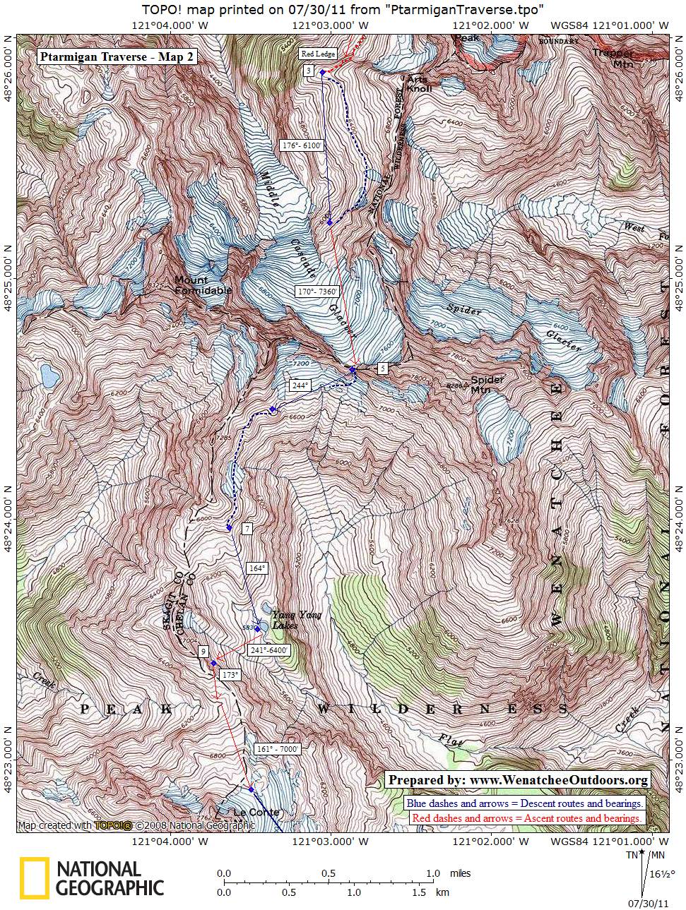
Trip Instructions. Take the Cascade Pass Trail to Cascade Pass (3.7 miles). From here, the route goes cross country over Cache Col, to Kool-Aid Lake, to Red Ledge and up, over to the Middle Cascade Glacier, up the Middle Cascade Glacier to the low gap west of Spider Mountain, down to Yang Yang Lakes, up toward Le Conte Mountain, over to the Le Conte Glacier, up to the gap north of Sentinel Peak, over to the South Cascade Glacier, over a gap at the head of that glacier, down to White Rock Lakes, over to the Dana Glacier, up to a gap east of Spire Point, down Itswoot Ridge to Cub Lake, up the Cub Lake Basin, down Bachelor Creek to Downey Creek, along the Downey Creek Trail to the trailhead, and down the Suiattle River Road to the gate. Our maps have most everything you really need to do the route but a written description of the route can be found in Fred Beckey’s Cascade Alpine Guide – Stevens Pass to Rainy Pass (the green guidebook). This posting about the route at Summit Post is also useful.
Our Additional Maps:


Date. First posted 7/30/2011.
Leave It Better Than You Found It. This should be every outdoor user’s goal. Pick up trash left by others, pull some noxious weeds along your route, throw branches over unwanted spur trails, don’t ride or walk wet trails when you’re leaving ruts/footprints deeper than ¼ inch…
Disclaimer. Treat this information as recommendations, not gospel. Conditions change, and those contributing these reports are volunteers–they may make mistakes or may not know all the issues affecting a route.You are still completely responsible for your decisions, your actions, and your safety. If you can’t live with that, you are prohibited from using our information.