This is a trip description paraphrased from the Leavenworth Chamber of Commerce Site.
ATTRACTIONS: This snowed-over road is an overlooked but very scenic ski option in the Leavenworth area. The landscape is much drier and more barren than the Tumwater and Icicle Canyons of Leavenworth and well worth the visit. This route is not part of a groomed trail system so the conditions de jour can vary from powdery to gloppy depending on the weather.
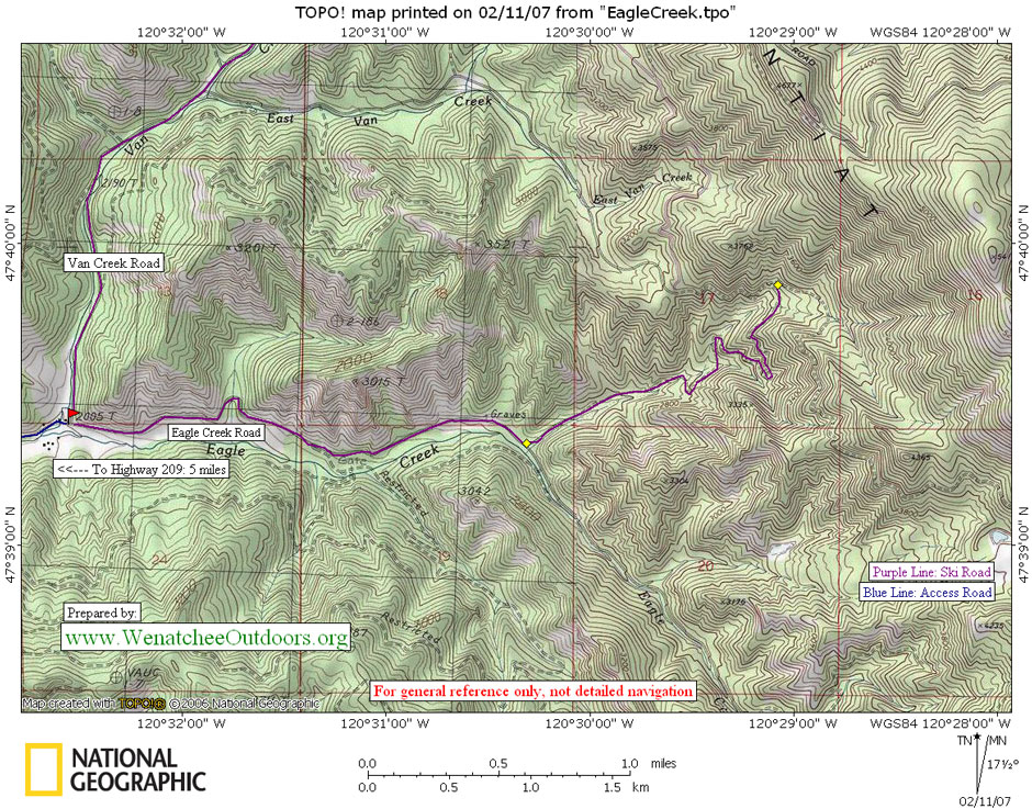
DISTANCES: Several options: 4 miles round trip for an easy trip, 8 to 10 miles roundtrip to access the scenic higher grounds of the trip.
ELEVATION GAIN: 400 feet of gain over the first two miles. An additional 900 feet of gain in the subsequent 1.75 miles described.
RECOMMENDED SKIERS: Adults and hearty teens.
ACCESS. At the east end of Leavenworth, turn north off of Highway 2 onto the Chumstick Road (there’s a traffic light here), following signs to Plain. After 2.1 miles turn right on Eagle Creek Road and follow this for 5 to 6 miles. Just beyond the Eagle Creek Ranch, park at the end of the paved road. Space is tight here so park perpendicularly on the right hand side and conserve as much space as possible for other visitors.
TRIP INSTRUCTIONS:
–Leave your car heading uphill along the unplowed road (don’t follow the left turn because that is a snowmobile trail during the winter months).
–At the one-mile mark, ski past the spur on your right side. After two miles you’ll come to a three-way intersection. This is a good turn around spot for a shorter, easier trip. These two miles of road climb about 400 vertical feet.
–If you still have plenty of energy, follow the left road for another 1.75 miles to a T-intersection. This segment of road climbs much more steeply (900 vertical feet over the 1.75 miles) and in some snow conditions you may want skinny climbing skins on the skis to make the climbing easier (see our article entitled ‘Skin Tips’ if you want to know more about skinny skins)
–The scenic vistas keep improving as you ski on, so if energy still allows it, turn right at the T-intersection and carry on.
–When you’re ready, turn around and retrace your route back to the car.
LAND OWNERSHIP. Route follows Forest Service Roads.
MAPS. See the topo map below for more information. Or, reference USGS 7.5 minute series: Van Creek and Chumstick Mtn.
PERMITS. None needed.
Leave It Better Than You found It. This should be every user’s goal. Pick up trash left by others, pull noxious weeds along your route, disperse old fire rings, throw branches over unwanted spur trails…
Disclaimer. Treat this information as recommendations, not gospel. Conditions change and those contributing these reports are volunteers–they may make mistakes or not know all the issues affecting a route. You are responsible for yourself, your actions, and your safety. If you won’t accept that responsibility, you are prohibited from using our information.