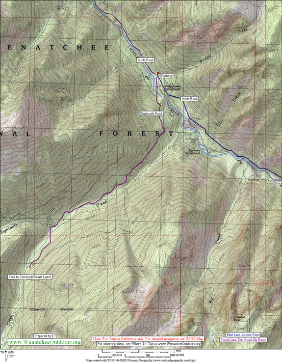
ATTRACTIONS: Snowed-over road with fine views down into the Icicle River and of the peaks along Icicle Ridge.
SKILL. 1 (beginner on heavy backcountry gear) or 2 (intermediate on light Nordic gear).
DISTANCE: Six-mile roundtrip to Eightmile Trailhead; eight-mile roundtrip to Lake Stuart/Colchuck Lake trailhead.
ELEVATION: Start at 2000 feet and end at 3300.
ACCESS: Drive about eight miles on the Icicle Creek Road (which eventually becomes Forest Service Road 76), southwest of Leavenworth. About one mile past the Eightmile Campground, Eightmile Road (Forest Service Road 7601) crosses Icicle Creek on your left. You can park on the main Icicle Creek Road in winter, or on Eightmile Road itself, depending on snow conditions.
TRIP INSTRUCTIONS: This ski simply follows the Eightmile Road. The trail starts off a little ragged, but improves with each swoosh of the skis. The lower mile of the road has been hammered pretty hard with snowmobile and truck tracks, but these gradually taper off into a quiet and clean trail with lots to appreciate. This road is one that we usually ignore in summer while rushing to get to the trailheads, but in winter, this route is a delight–if you can put up with the lower mile or so.
We took light, no-wax skis and used skins to climb up the first mile, which is the steepest (and combined with the ruts) make for more of an uphill march than a ski. Gradually the slope lessens so we shed the skins and continued to climb, but at a more gentle slope.
The trip down was a screamer. The further down, the faster and more rutted the trail. The descent would have been easier with metal edges, but we’ll bring them another time. In icy conditions, consider putting skins back on the skis (for control) for the final, mile-long plunge back to the car.
USES ALLOWED: Snowmobiling, skiing, snowshoeing.
CONS/HAZARDS: With old snow, the trail can be pretty icy and treacherous on lightweight cross-country skis.
FEES/PERMITS: None
MAPS: See map below for more information.
Wenatchee National Forest map, or Greentrails map #209S (Enchantments)
ADDITIONAL INFORMATION: This trip is easily extended by continuing up the road past the Stuart Lake trailhead. The road continues another 2-3 miles. You also have the option to leave the Eightmile Road and take one of the trails into the Alpine Lakes Wilderness.
TRIP REPORTERS/DATE: Bob, Carolyn, and Bill Bugert. 12/18/2005
Leave It Better Than You found It. This should be every user’s goal. Pick up trash left by others, pull noxious weeds along your route, disperse old fire rings, throw branches over unwanted spur trails…
Disclaimer. Treat this information as recommendations, not gospel. Conditions change and those contributing these reports are volunteers–they may make mistakes or not know all the issues affecting a route. You are responsible for yourself, your actions, and your safety. If you won’t accept that responsibility, you are prohibited from using our information.