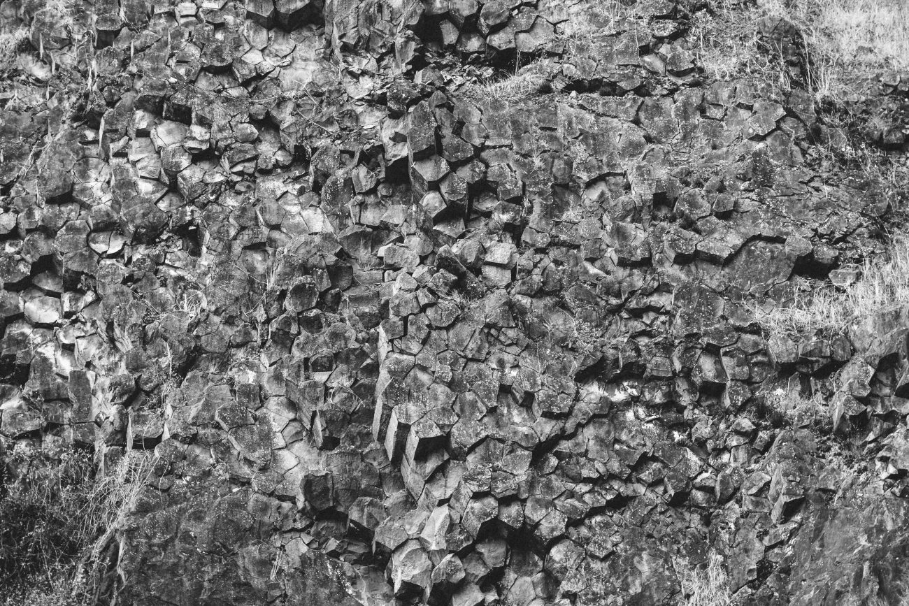
Echo Basin is one of several coulees west of Quincy, WA, near the Frenchman Hills formed as the Ice Age Floods raged over the surrounding cliffs. At the southwest end of Echo Basin is a large 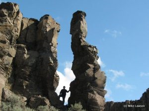 plateau, named Island Plateau. This plateau is not only lined with basalt columns, near the center sits an odd group of basalt columns and one free standing basalt spire. The purpose of this hike was to reach the spire by hiking around the south rim of Echo Basin. Along the way we passed a small lake, saw a variety of interesting geologic formations, and took pictures of the Echo Basin panorama. We also saw an area of diatomaceaous earth, Mount St. Helens ash, a large sand bar, signs of deer, and a few red-tail hawks. Wear good hiking boots — the terrain is quite rocky in places.
Skill: 2 (intermediate).
Fitness: 2- (easy intermediate)
Distance: 4 miles (round-trip)
Elevation gain: 200 ft
Best seasons: spring, summer, fall
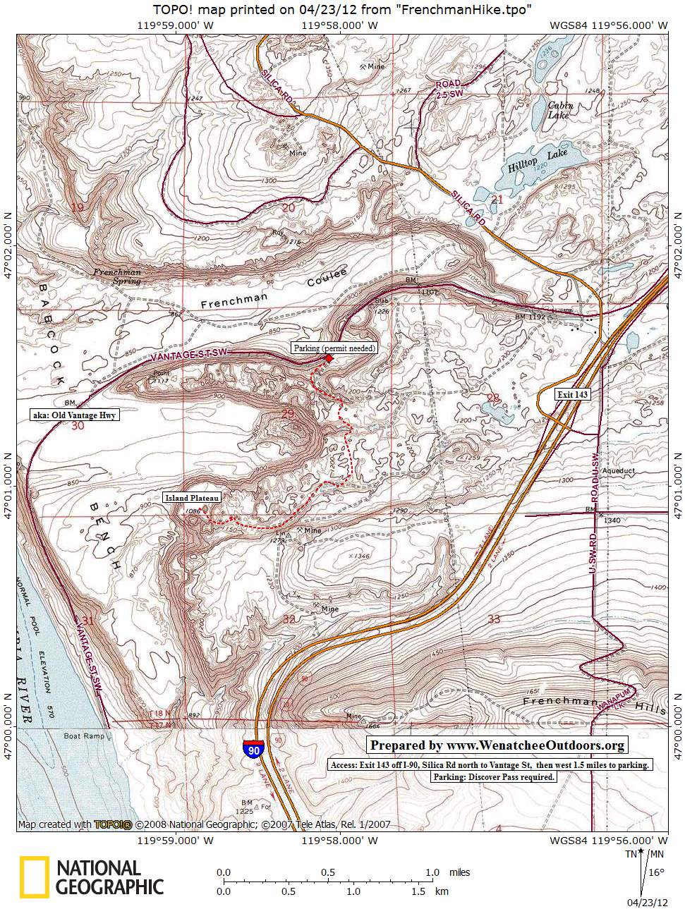
Access. Drive east of Quincy and take I-90 west to Exit 143 (Silica Road). Drive north on Silica Road about half mile then turn west (left) on Vantage St (aka the Old Vantage Highway). Follow this 1.5 miles to the parking area for primitive camping and for climbers accessing the Sunshine Wall. A Discover Pass is required (this parking lot does get patrolled).

Trip Instructions. Start hiking from the parking area at Agatha Tower, just southwest of The Feathers, in Frenchman Coulee. Stop at the top of Echo Basin alcove for a great view of the coulee. From that vantage point, you can see Island Plateau, which is the destination of this hike. Continue along the South rim of Echo Basin and then in a westerly direction to Island Plateau. Unless you are a skilled rock climber, the best approach down onto Island Plateau is from the South down a steep hill. There is a single basalt column, or spire (see photo), worth seeing while at the plateau. The spire stands at the front of the basalt monolith. Continue hiking across Island Plateau to the edge of the rim for a great view of Echo Basin and The Sunshine Wall in the distance. Be careful hiking down to the Plateau as it is fairly steep. Enjoy the hike, the scenery, and the interesting geology. See our photo and map of the route.
Map: See our topo map of this hike.
Hazards. Possible rattlesnakes in the summer months. Cliffs nearby.
Land Ownership. WA Department of Fish and Wildlife
Fees/Permits. Discover Pass required for parking.
Reporter (and date). Mike Lawson 03/20/2012
Leave It Better Than You Found It. This should be every outdoor user’s goal. Pick up trash left by others, pull some noxious weeds along your route, throw branches over unwanted spur trails, don’t ride or walk wet trails when you’re leaving ruts/footprints deeper than ¼ inch…
Disclaimer. Treat this information as recommendations, not gospel. Conditions change, and those contributing these reports are volunteers–they may make mistakes or may not know all the 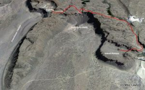 issues affecting a route.You are still completely responsible for your decisions, your actions, and your safety. If you can’t live with that, you are prohibited from using our information.
This post was originally published on 4/24/12.