
Photos and map courtesy of Roger Gervin. You can view additional photos on his website here. He wrote: “While Iron Peak is advertised as the ‘biggest bang for the buck’ in the Teanaway, this summit offers broader views and a lot more solitude… yours for the taking at the expense of adding only an additional 250 feet of elevation gain to your trip.”
Also known as Gene’s Peak, Teanaway Peak is one of many non-technical summits along the divide between Ingall’s Creek and the Teanaway River. While they all offer expansive views of the Stuart Range and other surrounding areas, Teanaway stands out as being one of the more lonesome, within a very attainable day’s reach from the trailhead.
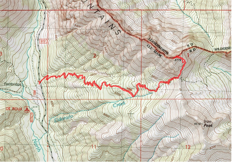
Map: See map below for more information.
Note: Use ‘Print Preview’ to orient/scale the map before printing.
Activity: Hiking, scrambling.
Nearest Town: Ellensburg.
Skill: 2 (intermediate). While the route is not much more than a hike, it involves some light scrambling and basic routefinding not recommended for the inexperienced hiker/scrambler.
Fitness: 2 (intermediate)
Distance: 7 miles round trip.
Elevation Gain: 2793 feet.
Best Seasons. The area is generally snow free from June – October.
Access. From Wenatchee, drive Highway 2 west 13 miles until the turnoff for Highway 97. At 48 miles, keep straight on WA-970. 3.4 miles later (51.4 miles from Wenatchee) turn right onto Teanaway Rd. After 10.2 miles, keep left to stay on what is now called North Fk Teanaway Rd. Keep right 2.6 miles after that. 1.3 miles later, turn left to stay on North Fk Teanaway Rd. After 7.2 miles, arrive at the trailhead for Iron Peak Trail No. 1399 (25 miles from Teanaway Rd Junction, approx. 76 miles from Wenatchee).


Trip Instructions. Begin hiking up Iron Peak trail No. 1399. After 2.75 miles of switchbacking, arrive at the Teanaway/Iron Peak Saddle at 6200 feet. Teanaway Peak is just to the north. At this point, leave the trail, and follow a bootpath with occasional cairns that heads generally NNE up the SE face of Teanaway Peak. The path eventually veers more NW to gain Teanaway’s NE summit ridge. Follow your nose and the path of least resistance (many options, all relatively easy) towards the summit of Teanaway Peak at 6779’, 3.5 miles from the trailhead.
Land Ownership. Wenatchee National Forest.
Fees/Permits. A Northwest Forest Pass is needed for parking at the trailhead.
Reporter. Roger Gervin, July 2015.
Leave It Better than You Found It. This should be every user’s goal. Pick up trash left by others, pull noxious weeds along your route, throw branches over unwanted spur trails, etc.
Disclaimer. Treat this information as recommendations, not gospel. Conditions change and those contributing these reports are volunteers–they may make mistakes or not know all the issues affecting a route. You are responsible for yourself, your actions, and your safety. If you won’t accept that responsibility, you are prohibited from using our information.