
Whether you’re just driving the Cascade Loop or spending more time exploring the North Cascades, keep in mind that Rainy Pass is a hiking hub with several excellent walks of varying length and 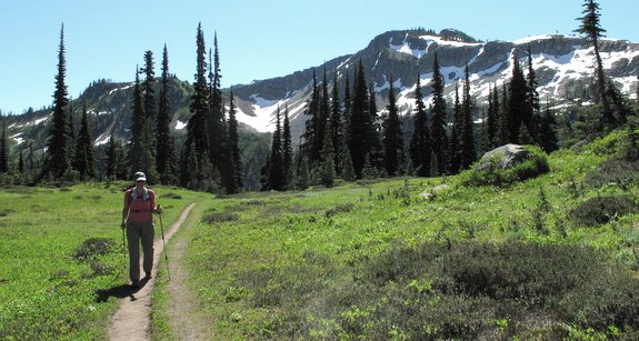 difficulty. Among the most popular options are the four-mile (round trip) hike taking you to Lake Ann, and the seven-mile Maple Pass Loop offering flower-filled alpine meadows and up-close-and-personal views of the rugged peaks typifying the North Cascades.
Access: Follow Highway 20 to Rainy Pass at milepost 157.5. Park in the rest area on the south side of the highway where you’ll find the trailhead for Trail No. 740, signed “Lake Ann-Maple Pass.” A Northwest Forest Pass is required to park (day passes can be purchased at the trailhead).
Map. View our topographic map of all the trails.
Activities Allowed: Hiking and trail running. These trails are closed to pack and saddle stock, motorized travel, and mountain bikes. These are popular trails and dogs doing these walks need to be leashed.
Land Ownership. Forest Service lands — the ridge reached at Maple Pass is on the boundary of North Cascade National Park.
Permit Required: Northwest Forest Pass.

Lake Ann
Skill: 1
Fitness: 1+ or 2-
Length: 4 miles (round trip)
Trip Instructions:
– Follow 740 trail about 1.3 miles until you reach an intersection with a spur trail at about 5,400 feet.
– Take the left fork (the lower trail) toward Lake Ann, and follow it another 0.5 miles along two shallow lakelets and around marshes. The trail remains quite level and leads to the east edge of Lake Ann.
– Camping is prohibited within 0.25 miles of the lake.
– The higher trail leading to Heather Pass and Maple Pass is visible from the lake.
Heather Pass
Skill: 2
Fitness: 2
Length: 6 miles (round trip)
Trip Instructions:
– Follow same trail as Lake Ann, but keep right on the spur encountered after 1.3 miles.
– The trail ascends a large rockslide, and then traverses toward Heather Pass.
– At 2.5 miles, the trail reaches Heather Pass (el: 6,200′). To the west, you’ll see Black Peak, Lewis Peak, and the cirque of Wing Lake (out of sight under the peak).
– Another trail traverses steep hillsides of boulders and snow toward Lewis Lake and Wing Lake, and camping is available near Wing Lake.
Maple Pass / Loop
Skill: 2
Fitness: 2
Length: 8 miles round trip
Elevation Gain: 1800ft
Trip Instructions:
– Follow the route above to Heather Pass.
– From Heather Pass, continue on main trail, contouring above the cliffs rimming Lake Ann.
– The trail reaches Maple Pass at about the 3.5-mile mark (el 6,600′).
-Continue climbing for another mile, reaching the shoulder of Frisco Mountain at 6,850 feet.
– The loop then dives off into the hanging valley, filled with meadows and blooming flowers (Rainy Lake is visible some 1,700 feet below).
– Descend down to the paved Rainy Lake Trail and follow that 0.5 miles back to the start.
Leave It Better Than You Found It: This should be every outdoor user’s goal. Pick up trash left by others, pull noxious weeds along your route, disperse old fire rings (they encourage more fires), throw branches over spur trails and spurs between switchbacks (make it harder to do the wrong thing than the right thing).
Important Disclaimer: Treat this information as recommendations, not gospel. Things change, conditions change, and those contributing these reports are volunteers–they may make mistakes, fail to give complete information, or may not know all the issues affecting a route. If things go wrong, you are completely responsible for yourself and your actions. If you won’t assume that responsibility, you are prohibited from using our information.
This post was originally published on 7/19/14.


