by Matthew Tangeman
Ask just about any Methow Valley local what their go-to mountain bike ride is, and there is a fair chance they’ll respond, “Buck Mountain.” A balanced mixture of Forest Service Roads, jeep roads, and fantastic singletrack, Buck Mountain has a little for everyone complete with spectacular ridgeline views overlooking the Chewuch and Methow valleys.
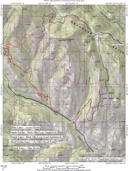
Maps: See our topo map attached. Note: Use ‘Print Preview’ to orient/scale the map before printing.
Activity: Mountain biking, trail running.
Nearest Town: Winthrop.
Skill: 2 (intermediate).
Fitness: 2 (intermediate).
Distance: 13 miles (original loop), 10 miles (new alternate loop).
Elevation Gain: 1300 feet (original loop), 1000 feet (new alternate loop).
Best Season: mid-late spring through fall. Best done early morning or evening in summer, as ride has southern exposure and can be very hot. 
Access. The new Buck Lake trailhead is 12 miles from Winthrop. Drive 8 miles up the West Chewuch road to the Buck Lake turn on the left and proceed 4 miles to Buck Lake. Do not park in the campground. No recreational pass is required to park at Buck Lake.
Trip Instructions for New, Alternate Loop. From Buck Lake, ride Road 155 around the north shore. Continue left at a junction at approx. 1 mile. If confused, simply follow the bright yellow MVSTA signs. After passing multiple spur roads, reach a gate and singletrack trail at a saddle. Follow this fast, open trail as it traverses east and eventually descends a sage-choked ridgeline with views all around. It’s a good place to get your speed up, but watch for sandy corners. At a trail junction, turn left (south) and soon hairpin north into the First Creek drainage. Continue on this trail until reaching a potentially confusing junction at approx. 9 miles. Check for MVSTA signs and follow the ones pointing to Buck Lake. Turn left (north), and follow Road 140 through some ups and downs and then a steady climb to return to the trailhead.
Other Issues. The standard loop that most riders are familiar with (starting in Cub Valley) is closed due to logging as of July 2013. The information presented here delineates an alternate route recommended by the Methow Valley Sport Trails Association, starting from Buck Lake. Check with Winthrop Mountain Sports or Methow Cycle and Sport in Winthrop for current closures and info.
Land Ownership. The route lies primarily on Okanogan National Forest and Methow Wildlife Area lands.
Fees/Permits: None needed as of July 2013.
Updated Condition Reports. Up-to-date trail reports can be found at Winthrop Mountain Sport’s website here.
Trip Reporter: Matthew Tangeman, July 2013.
More information. Winthrop Mountain Sports has a good post about this trip (we borrowed a few details from their post to improve this post). See their article here.
Leave It Better than You Found It. This should be every user’s goal. Pick up trash left by others, pull noxious weeds along your route, throw branches over unwanted spur trails, etc.
Preserving the Trails. Please stay off trails when they are soft or wet enough that you’re leaving foot prints or wheel ruts deeper than 1/4 inch (or horse prints deeper than ½ inch). All of these prints hold and channel water, greatly accelerating erosion. When the trails are soft, ask whether a 100 people could use the trails in the same way you’re using them without messing u p the surface? If the answer is ‘no’ please turn around. Be aware that not all use is equal–horses need the driest firmest trails, then bikes, then walkers.
Disclaimer. Treat this information as recommendations, not gospel. Conditions change and those contributing these reports are volunteers–they may make mistakes or not know all the issues affecting a route. You are responsible for yourself, your actions, and your safety. If you won’t accept that responsibility, you are prohibited from using our information.