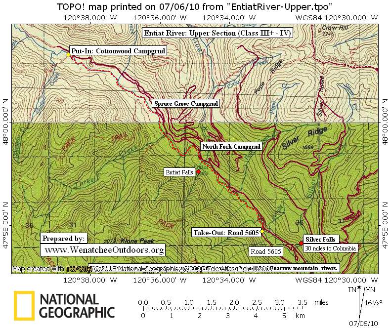

Option 1: Cottonwood Run of the Upper Entiat – Cottonwood Campground to Road 5605.
Distance: 6.7 miles. (Exit above Box Canyon)
Maps: See map below for more information.
Difficulty: Class III+ and IV (exit before Box Canyon). Fitness: 3 (advanced)
Average Gradient: 94 fpm
Gauge Information:
Min Sug. Level: 1000 cfs
Max Sug. Level: 3000 cfs
The source of the information above is the American Whitewater website. River conditions are subject to change, especially after storms or floods. For more the most up-to-date and detailed information or to view photos and user comments, check this river’s information at American Whitewater.
Access: Drive 97A just north of the bridge crossing the Entiat River. Turn (west) and drive up the Entiat River Road about 30 miles to Silver Falls. Road 5605 (the Take-Out) splits off the Entiat River Road on your left about 0.75 miles beyond the trail to Silver Falls while the Put-In at Cottonwood Campground is about 7.4 miles upstream of the Silver Falls Trail.
Option 2: The Canyon (Lake Creek Campgound to River Mile 26)
Difficulty: 1V+. Length 3 miles. Fitness Level: 3 (advanced)
Put-In. Start at Lake Creek Campground about 28 miles up the Entiat River Road from Highway 97A.

Take Out. Exit the river near River Mile 26 about 3 miles downstream of put-in. this is roughly 25.5 miles up the Entiat River Road.
Scouting. The upper part of this run can be scouted from the campground. There are also a number of pullouts along the Entiat River Road that should be used to scout the rapids and to check for woody hazards. This run is prone to having wood in it and is very hazardous when such blockages exist.
Map. See our topo map.
Levels and Gauges. Use the same info as mentioned above.
Condition Update. As of the summer of 2011, some very dangerous sweepers and log jams were reported on the Canyon Run. These are unlikely to wash out until a higher-than-normal spring flood.
More Info. To find out if anyone has run the river and reported the condition of the run with Leavenworth Mountain Sports (509) 548-7864 and/or Osprey Rafting in Leavenworth. There is also a good write-up of this run from 2008 written by Chris Arnold at this page (find the ‘Entiat River (The Canyon)’ entry in the alphabetic index).

Leave It Better Than You Found It: This should be every outdoor user’s goal. Pick up trash left by others, pull some noxious weeds along your route, throw branches over unwanted spur trails, don’t ride or walk wet trails when you’re leaving ruts/footprints deeper than ¼ inch…
Disclaimer. Treat this information as recommendations, not gospel. Conditions change and those contributing these reports are volunteers–they may make mistakes or not know all the issues affecting a route. You are responsible for yourself, your actions, and your safety. If you won’t accept that responsibility, you are prohibited from using our information.