 The Chatter Creek Trail climbs steeply from the Icicle Creek Valley up through forests of Ponderosa pine and Douglas fir into the sub alpine zone of Icicle Ridge with its granite crags and larch glades. Along the way you have cloistered moments of introspection in the woods and expansive moments in the open for taking in views.
Activities: Hiking
Nearest Town: Leavenworth
Skill Level: 2
Fitness Level: 2
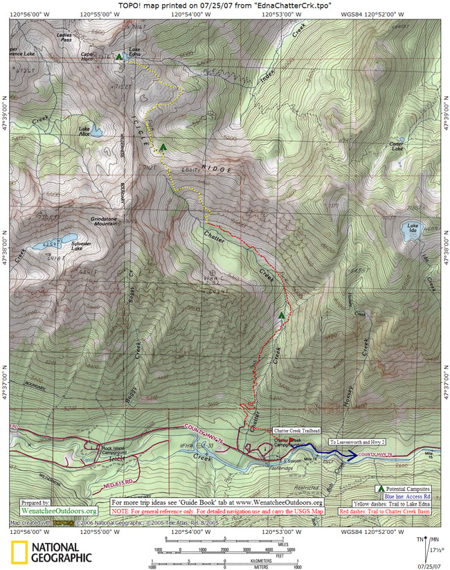
Distance: Roundtrip to the basin: 5 miles
Elevation: Elevation gain: 2500 feet
Access:
–Follow US Highway 2 West through Leavenworth and turn left at the end of town on Icicle Road (follow signs to the Leavenworth National Fish Hatchery, there is a large gas station at the corner). If you are traveling Eastbound on Highway 2 over Stevens Pass go right on Icicle Road when you first enter Leavenworth.
–The main road hooks right before the entrance to Sleeping Lady Resort.
–From here, follow the Icicle Creek Road about 14.5 miles and turn right into the parking lot for the Chatter Creek Trail, which is different than the entrance to the Chatter Creek Campground. If you reach the Chatter Creek Campground or the guard station, you’ve gone too far.
Trip Instructions:
–Follow the old road from trailhead for about 100 yards to the point where it splits.
–Take the right fork and continue climbing steeply as the trail follows the creek.
–The steepness gradually tapers off and, at 2.5 miles you reach an open basin. Turn around for a 5-mile roundtrip.
–The trail continues from this basin for an 11.5-mile roundtrip hike to Lake Edna. See the Lake Edna trip description for more details.
Recommended Season: July to mid-September
Cons/Hazards: If you don’t enjoy climbing, this trail isn’t for you. Also, on a hot summer’s day this trail, even though moderately shaded, gets a lot of sun exposure and can be quite a cooker.
Fees/Permits:
–A Northwest Forest pass is required at the trailhead. If you don’t have one, you can purchase the pass a few miles farther up the road at the Icicle Gorge trailhead.
— A hiking permit is also required for both day and overnight hikers, but can be picked up at the trailhead (self register).
Additional Information:
–Contact the Leavenworth Ranger Station—phone (509) 548-6977—and ask for information about trail No. 1580.
–Information for this trip description was compiled from our own trip reporter and 100 Hikes in Washington’s Alpine Lakes, published by The Mountaineers.
Reporter: Andy Dappen, 7/21/07
Map: View our topo map below for more information. Note: use ‘Print Preview’ before printing to properly scale this map to a full sheet of paper.
May 2008 Update: The Icicle River Road was washed out by a massive land/snow slide in mid May near Doctor Creek. Motorized access to this trail will not be possible throughout all of June and probably well into the summer. Check with the Forest Service (509-548-6977,then 0, for front desk) to learn the status of the road. You can drive to the washout area, park nearby, and walk around the slide (not real easy but doable) and then walk or ride a mountain bike along the road–which actually provides a rather unique opportunity to have the trails leaving from the upper Icicle to yourself.
Leave It Better Than You Found It. This should be every outdoor user’s goal. Pick up trash left by others, pull some noxious weeds along your route, throw branches over unwanted spur trails, don’t ride or walk wet trails when you’re leaving ruts/footprints deeper than ¼ inch…
Disclaimer. Treat this information as recommendations, not gospel. Conditions change, and those contributing these reports are volunteers–they may make mistakes or may not know all the issues affecting a route. You are still completely responsible for your decisions, your actions, and your safety. If you can’t live with that, you are prohibited from using our information.