Reporter: Molly Steere
Attractions. If you like scenic fire roads and you have half a day or more to spare, this is a great ride–especially if you can arrange a shuttle to drop you off and pick you up so that the ride can be done as a traverse rather than an out-and-back. Your posse will earn their views with the ride up to Maverick Saddle, but you can decide how much punishment to dole out depending on where you park the car. Maverick Saddle to Sugarloaf Peak Lookout is a long undulating traverse boasting views of Lake Wenatchee, Fish Lake, and the Glacier Peak Wilderness Area. The combination of burn area, abundant wildflowers, and panoramic views are phenomenal. Sugarloaf Lookout, established in 1914, is staffed every summer – it’s a choice spot to eat lunch and visit with the on-duty ranger to learn a little about his/her duties and the 1970 and 1994 fires that threatened the structure. From Sugarloaf, there are several ways to get down to the Leavenworth area in a hurry. This rider left her car at the end of Eagle Creek Road and bombed down the smooth Forest Road 7520.
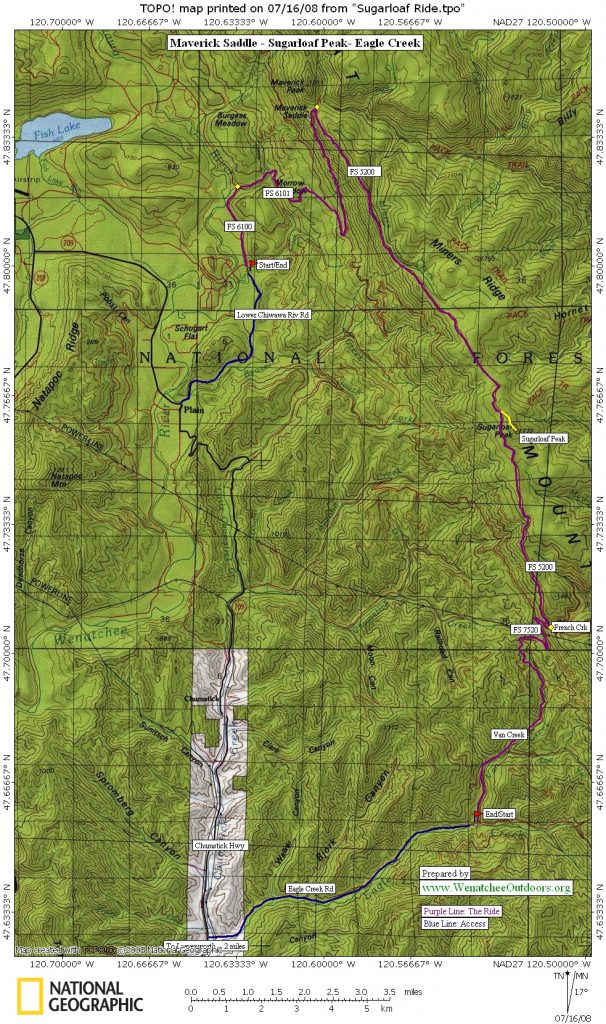
Access. Drive up Chumstick Highway about 14 miles to Plain. Just past Plain and milepost 14, turn right onto Chiwawa Loop. After about 3.5 miles, take a right onto Lower Chiwawa River Road (shortly before crossing the river). The pavement ends after 100 yards and turns into FS 6100. This ride has a choice in start points (depending on how much of a climb you want) but trip description will start from the end of the pavement. The pickup as described below is 5.5 miles up the Eagle Creek Road (which takes off from the Chumstick Highway 2 miles north of Leavenworth) at the intersection with Van Creek (FS 7520).
Distance. Many options are possible. As an out-and back from Chiwawa River Road, the ride is 28 miles. As a traverse as described below it’s 24.2 miles (from pavement to pavement). If you completed the traverse but rode all the way back to Leavenworth so there was no need for a pick-up, the ride would be 32 miles.
Elevation. Lower Chiwawa Creek Rd: 2,014 feet. Sugarloaf Peak Lookout: 5,814 feet. Gain: 3,800 feet.
Difficulty. This ride is well suited for cross-country mountain bikes. There are a few loose rocky sections on the climb up but, overall, the ride is not technical. If you have the ability to lock out your shocks on the climb up, do it. Keep your speed in check on the way down if you aren’t accustomed to loose gravel.
Trip Instructions:
- From the start of Chiwawa River Road/FS 6100, ride 1.5 of easy ascent.
- At the T in the road, turn right toward Sugarloaf Peak Lookout on FS 6101.
- At 2.1 miles you’ll reach an intersection. Continue straight on FS 6101. The next couple of miles are nicely shaded.
- At 4.5 miles you’ll come to a campground/picnic area. Follow 6101 left. This is the start of more difficult climbing because of the steeper, rockier terrain. Try taking your bulging, oxygen-starved eyes off the ground and looking left to take in the views of Lake Wenatchee and Fish Lake.
- At about 7.0 miles you’ll reach a hairpin turn and shaded picnic area at Maverick Saddle. This is a great place to get off your saddle and take in the views from different vantages.
- Take a right onto FS 5200 (still referred to as FS 6101 on some maps) toward Sugarloaf Peak Lookout. The next seven miles are an undulating — more up than down — traverse to the lookout. Enjoy the panoramic view as you enter into the burn area.
- At 13.6 miles you’ll come to the turn-off for the lookout. Head left up the final section of road to the lookout.
- The Sugarloaf Peak Lookout out is at 14.0 miles. Pull out your lunch and enjoy the views you earned. The on-duty employee is happy to disperse a little knowledge if you’re so inclined.
- Zero out your odometer at the lookout and head back down the road you came in on.
- At .4 miles take a left onto FS 5200 (still referred to as FS 6101on some maps).
- At 4.8 miles you come to a big intersection with a pit toilet and signage. Take a right toward Eagle Creek Road. Road is posted as FS 7520 (FS 7801 on some maps, turning into FS 7520).
- At 10.2 miles you’ll reach Eagle Creek Road. This is a good place to be picked up but if transportation is an issue, turn right and pedal 5.5 miles down Eagle Creek to the Chumstick Highway, then turn left and ride 2.25 miles back to Leavenworth.
Hazards. The ride up to Maverick Saddle and Sugarloaf Peak Lookout has more deer traffic than car traffic, but be alert on the way down from Sugarloaf – FS 7520 is a well-used road for cars and trucks. This is also a popular route for dirt bikers.
Land Ownership. Forest Service lands and roads.
Permits. A Northwest Forest Pass is needed to park at any trailhead. Wide spots in the road (though sometimes few and far between) are fair game.
Maps. See our map below (print in portrait mode on 8.5″ x 14″ paper). Also see USGS Sugarloaf Peak or Green Trails Plain.
Date of Report: July 2008
Leave It Better Than You Found It. This should be every outdoor user’s goal. Pick up the trash others have left behind, pull noxious weeds along your route, disperse fire rings found at campsites (they encourage more fires), throw logs and branches over spur trails and spurs between switchbacks (make it harder to do the wrong thing than the right thing).
Disclaimer. Treat this information as recommendations, not gospel. Things change, conditions change, and those contributing these reports are volunteers–they may make mistakes, fail to give complete information, or may not know all the issues affecting a route. You are completely responsible for your decisions, actions, and safety. If you won’t accept that responsibility, you are prohibited from using our information.